You are here: Home > Network List > TA - USArray Transportable Network (new EarthScope stations) Stations List
> Station Q24A Divide, CO, USA > Earthquake Result Viewer
Q24A Divide, CO, USA - Earthquake Result Viewer

| Earthquake location: |
East Of Kuril Islands |
| Earthquake latitude/longitude: |
46.9/155.2 |
| Earthquake time(UTC): |
2009/01/15 (015) 17:49:39 GMT |
| Earthquake Depth: |
36 km |
| Earthquake Magnitude: |
6.9 MB, 7.5 MS, 7.4 MW, 7.4 MW |
| Earthquake Catalog/Contributor: |
WHDF/NEIC |
|
| Network: |
TA USArray Transportable Network (new EarthScope stations) |
| Station: |
Q24A Divide, CO, USA |
| Lat/Lon: |
38.96 N/105.15 W |
| Elevation: |
2775 m |
|
| Distance: |
68.6 deg |
| Az: |
55.644 deg |
| Baz: |
313.388 deg |
| Ray Param: |
0.056161042 |
| Estimated Moho Depth: |
37.25 km |
| Estimated Crust Vp/Vs: |
2.05 |
| Assumed Crust Vp: |
6.159 km/s |
| Estimated Crust Vs: |
3.008 km/s |
| Estimated Crust Poisson's Ratio: |
0.34 |
|
| Radial Match: |
98.04142 % |
| Radial Bump: |
264 |
| Transverse Match: |
94.656654 % |
| Transverse Bump: |
370 |
| SOD ConfigId: |
2834 |
| Insert Time: |
2010-03-07 05:46:26.546 +0000 |
| GWidth: |
2.5 |
| Max Bumps: |
400 |
| Tol: |
0.001 |
|
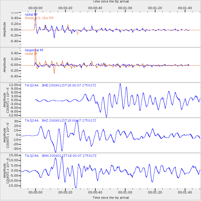
Signal To Noise
| Channel | StoN | STA | LTA |
| TA:Q24A: :BHZ:20090115T18:00:07.275017Z | 19.274519 | 1.085068E-5 | 5.6295465E-7 |
| TA:Q24A: :BHN:20090115T18:00:07.275017Z | 8.875816 | 3.4571945E-6 | 3.895072E-7 |
| TA:Q24A: :BHE:20090115T18:00:07.275017Z | 5.8764052 | 2.791156E-6 | 4.749768E-7 |
| Arrivals |
| Ps | 6.5 SECOND |
| PpPs | 18 SECOND |
| PsPs/PpSs | 24 SECOND |


