You are here: Home > Network List > TA - USArray Transportable Network (new EarthScope stations) Stations List
> Station Q24A Divide, CO, USA > Earthquake Result Viewer
Q24A Divide, CO, USA - Earthquake Result Viewer
| Earthquake location: |
Tonga Islands |
| Earthquake latitude/longitude: |
-20.8/-174.3 |
| Earthquake time(UTC): |
2009/07/30 (211) 20:05:34 GMT |
| Earthquake Depth: |
10 km |
| Earthquake Magnitude: |
5.9 MB, 5.7 MS, 5.8 MW, 5.7 MW |
| Earthquake Catalog/Contributor: |
WHDF/NEIC |
|
| Network: |
TA USArray Transportable Network (new EarthScope stations) |
| Station: |
Q24A Divide, CO, USA |
| Lat/Lon: |
38.96 N/105.15 W |
| Elevation: |
2775 m |
|
| Distance: |
87.8 deg |
| Az: |
46.791 deg |
| Baz: |
240.98 deg |
| Ray Param: |
0.04306554 |
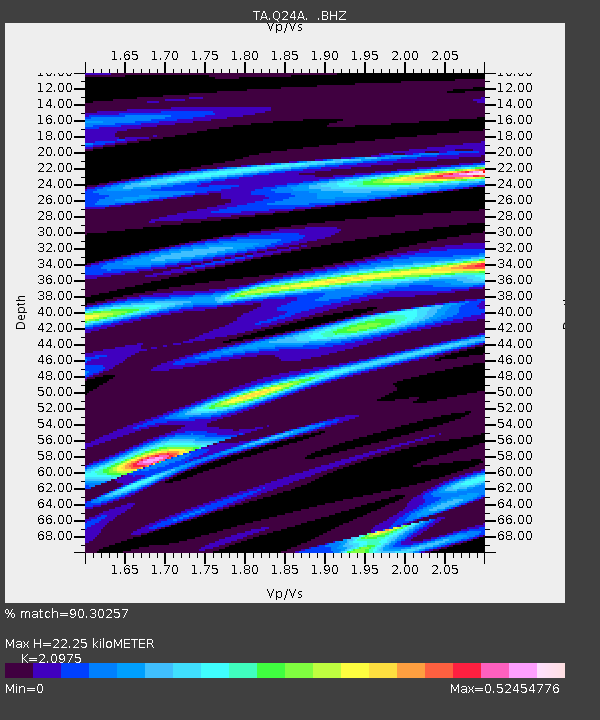
| Estimated Moho Depth: |
22.25 km |
| Estimated Crust Vp/Vs: |
2.10 |
| Assumed Crust Vp: |
6.159 km/s |
| Estimated Crust Vs: |
2.936 km/s |
| Estimated Crust Poisson's Ratio: |
0.35 |
|
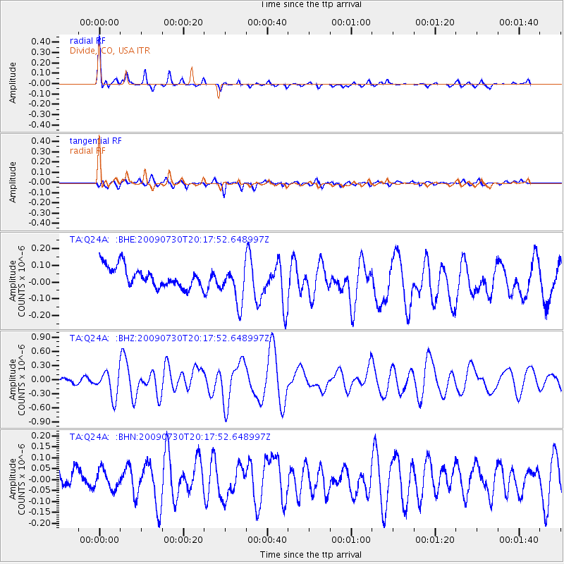
| Radial Match: |
90.30257 % |
| Radial Bump: |
277 |
| Transverse Match: |
62.35635 % |
| Transverse Bump: |
351 |
| SOD ConfigId: |
2622 |
| Insert Time: |
2010-03-07 05:46:27.537 +0000 |
| GWidth: |
2.5 |
| Max Bumps: |
400 |
| Tol: |
0.001 |
|
Signal To Noise
| Channel | StoN | STA | LTA |
| TA:Q24A: :BHZ:20090730T20:17:52.648997Z | 5.5808654 | 2.8505735E-7 | 5.1077624E-8 |
| TA:Q24A: :BHN:20090730T20:17:52.648997Z | 0.97652596 | 4.661867E-8 | 4.7739306E-8 |
| TA:Q24A: :BHE:20090730T20:17:52.648997Z | 1.9040552 | 1.1610344E-7 | 6.097693E-8 |
| Arrivals |
| Ps | 4.0 SECOND |
| PpPs | 11 SECOND |
| PsPs/PpSs | 15 SECOND |


