You are here: Home > Network List > TA - USArray Transportable Network (new EarthScope stations) Stations List
> Station Q24A Divide, CO, USA > Earthquake Result Viewer
Q24A Divide, CO, USA - Earthquake Result Viewer
| Earthquake location: |
Off Coast Of Costa Rica |
| Earthquake latitude/longitude: |
7.9/-85.6 |
| Earthquake time(UTC): |
2009/08/13 (225) 09:37:35 GMT |
| Earthquake Depth: |
10 km |
| Earthquake Magnitude: |
5.8 MW, 5.3 MB |
| Earthquake Catalog/Contributor: |
WHDF/NEIC |
|
| Network: |
TA USArray Transportable Network (new EarthScope stations) |
| Station: |
Q24A Divide, CO, USA |
| Lat/Lon: |
38.96 N/105.15 W |
| Elevation: |
2775 m |
|
| Distance: |
35.5 deg |
| Az: |
333.37 deg |
| Baz: |
145.284 deg |
| Ray Param: |
0.07717723 |
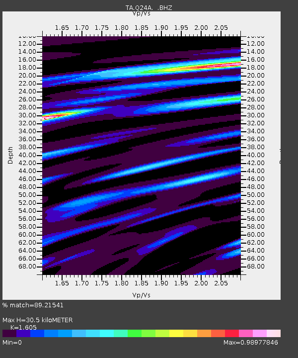
| Estimated Moho Depth: |
30.5 km |
| Estimated Crust Vp/Vs: |
1.61 |
| Assumed Crust Vp: |
6.159 km/s |
| Estimated Crust Vs: |
3.837 km/s |
| Estimated Crust Poisson's Ratio: |
0.18 |
|
| Radial Match: |
89.21541 % |
| Radial Bump: |
295 |
| Transverse Match: |
75.80709 % |
| Transverse Bump: |
400 |
| SOD ConfigId: |
2622 |
| Insert Time: |
2010-03-07 05:46:31.360 +0000 |
| GWidth: |
2.5 |
| Max Bumps: |
400 |
| Tol: |
0.001 |
|
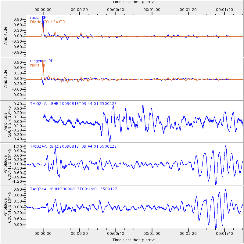
Signal To Noise
| Channel | StoN | STA | LTA |
| TA:Q24A: :BHZ:20090813T09:44:01.550012Z | 5.316825 | 2.6715367E-7 | 5.0246843E-8 |
| TA:Q24A: :BHN:20090813T09:44:01.550012Z | 2.9320376 | 1.0847121E-7 | 3.6995164E-8 |
| TA:Q24A: :BHE:20090813T09:44:01.550012Z | 2.3177269 | 1.3681677E-7 | 5.9030576E-8 |
| Arrivals |
| Ps | 3.2 SECOND |
| PpPs | 12 SECOND |
| PsPs/PpSs | 15 SECOND |


