You are here: Home > Network List > TA - USArray Transportable Network (new EarthScope stations) Stations List
> Station Q24A Divide, CO, USA > Earthquake Result Viewer
Q24A Divide, CO, USA - Earthquake Result Viewer
| Earthquake location: |
Near Coast Of Venezuela |
| Earthquake latitude/longitude: |
10.7/-67.9 |
| Earthquake time(UTC): |
2009/09/12 (255) 20:06:24 GMT |
| Earthquake Depth: |
10 km |
| Earthquake Magnitude: |
6.3 MB, 6.4 MS, 6.3 MW, 6.3 MW |
| Earthquake Catalog/Contributor: |
WHDF/NEIC |
|
| Network: |
TA USArray Transportable Network (new EarthScope stations) |
| Station: |
Q24A Divide, CO, USA |
| Lat/Lon: |
38.96 N/105.15 W |
| Elevation: |
2775 m |
|
| Distance: |
43.5 deg |
| Az: |
316.726 deg |
| Baz: |
120.21 deg |
| Ray Param: |
0.07252755 |
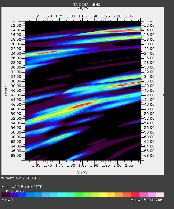
| Estimated Moho Depth: |
13.5 km |
| Estimated Crust Vp/Vs: |
2.10 |
| Assumed Crust Vp: |
6.159 km/s |
| Estimated Crust Vs: |
2.936 km/s |
| Estimated Crust Poisson's Ratio: |
0.35 |
|
| Radial Match: |
92.568565 % |
| Radial Bump: |
326 |
| Transverse Match: |
74.87738 % |
| Transverse Bump: |
347 |
| SOD ConfigId: |
2622 |
| Insert Time: |
2010-03-07 05:46:37.265 +0000 |
| GWidth: |
2.5 |
| Max Bumps: |
400 |
| Tol: |
0.001 |
|

Signal To Noise
| Channel | StoN | STA | LTA |
| TA:Q24A: :BHZ:20090912T20:13:57.050005Z | 7.3654194 | 7.200036E-7 | 9.7754594E-8 |
| TA:Q24A: :BHN:20090912T20:13:57.050005Z | 2.1236048 | 2.1934596E-7 | 1.0328945E-7 |
| TA:Q24A: :BHE:20090912T20:13:57.050005Z | 2.353898 | 3.585671E-7 | 1.5232908E-7 |
| Arrivals |
| Ps | 2.5 SECOND |
| PpPs | 6.5 SECOND |
| PsPs/PpSs | 9.0 SECOND |


