You are here: Home > Network List > MB - Montana Regional Seismic Network Stations List
> Station JTMT Jette Lake, Montana > Earthquake Result Viewer
JTMT Jette Lake, Montana - Earthquake Result Viewer
| Earthquake location: |
Tonga Islands |
| Earthquake latitude/longitude: |
-18.9/-175.4 |
| Earthquake time(UTC): |
2019/11/11 (315) 23:03:27 GMT |
| Earthquake Depth: |
10 km |
| Earthquake Magnitude: |
6.1 Mww |
| Earthquake Catalog/Contributor: |
NEIC PDE/us |
|
| Network: |
MB Montana Regional Seismic Network |
| Station: |
JTMT Jette Lake, Montana |
| Lat/Lon: |
47.75 N/114.28 W |
| Elevation: |
1469 m |
|
| Distance: |
85.9 deg |
| Az: |
36.318 deg |
| Baz: |
236.185 deg |
| Ray Param: |
0.044424452 |
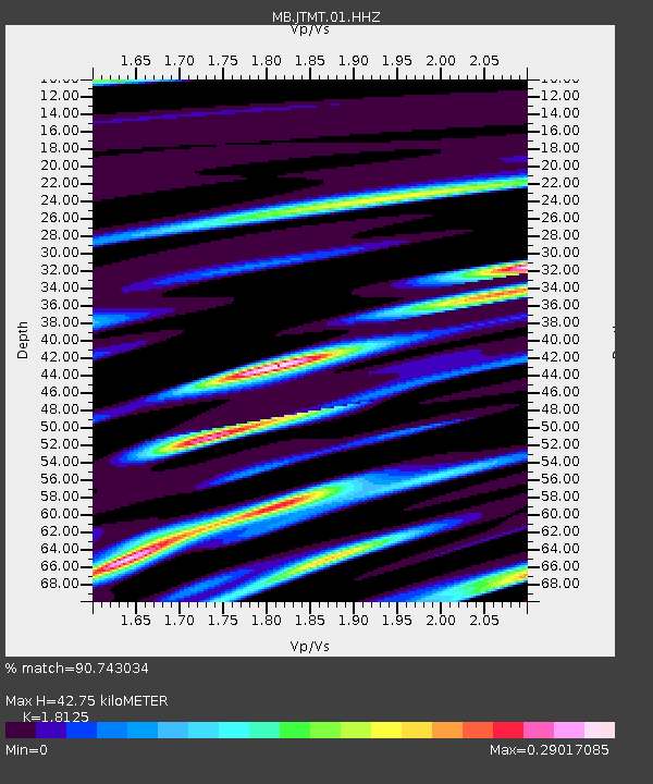
| Estimated Moho Depth: |
42.75 km |
| Estimated Crust Vp/Vs: |
1.81 |
| Assumed Crust Vp: |
6.622 km/s |
| Estimated Crust Vs: |
3.654 km/s |
| Estimated Crust Poisson's Ratio: |
0.28 |
|
| Radial Match: |
90.743034 % |
| Radial Bump: |
351 |
| Transverse Match: |
78.57585 % |
| Transverse Bump: |
260 |
| SOD ConfigId: |
19951751 |
| Insert Time: |
2019-11-25 23:10:24.657 +0000 |
| GWidth: |
2.5 |
| Max Bumps: |
400 |
| Tol: |
0.001 |
|

Signal To Noise
| Channel | StoN | STA | LTA |
| MB:JTMT:01:HHZ:20191111T23:15:35.769982Z | 1.5677568 | 3.4499477E-9 | 2.200563E-9 |
| MB:JTMT:01:HHN:20191111T23:15:35.769982Z | 2.683727 | 6.1182552E-9 | 2.2797606E-9 |
| MB:JTMT:01:HHE:20191111T23:15:35.769982Z | 2.5169663 | 2.6415117E-9 | 1.0494823E-9 |
| Arrivals |
| Ps | 5.4 SECOND |
| PpPs | 18 SECOND |
| PsPs/PpSs | 23 SECOND |


