You are here: Home > Network List > TS - TERRAscope (Southern California Seismic Network) Stations List
> Station PAS Pasadena, California, USA > Earthquake Result Viewer
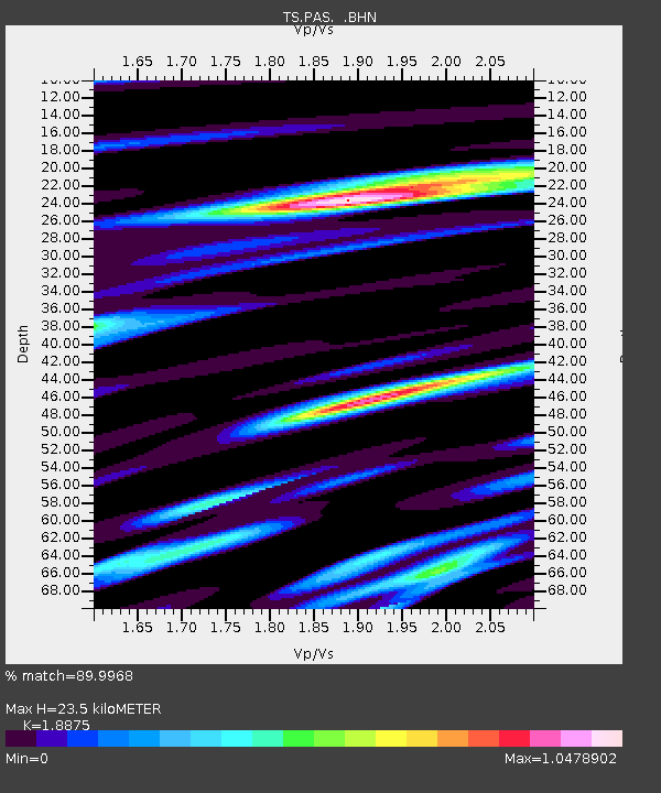
PAS Pasadena, California, USA - Earthquake Result Viewer
| Earthquake location: |
Fiji Islands Region |
| Earthquake latitude/longitude: |
-21.4/-176.6 |
| Earthquake time(UTC): |
1990/06/23 (174) 21:38:22 GMT |
| Earthquake Depth: |
209 km |
| Earthquake Magnitude: |
6.3 MB, 6.5 UNKNOWN |
| Earthquake Catalog/Contributor: |
WHDF/NEIC |
|
| Network: |
TS TERRAscope (Southern California Seismic Network) |
| Station: |
PAS Pasadena, California, USA |
| Lat/Lon: |
34.15 N/118.17 W |
| Elevation: |
295 m |
|
| Distance: |
78.3 deg |
| Az: |
46.17 deg |
| Baz: |
234.175 deg |
| Ray Param: |
0.049195554 |
| Estimated Moho Depth: |
23.5 km |
| Estimated Crust Vp/Vs: |
1.89 |
| Assumed Crust Vp: |
6.1 km/s |
| Estimated Crust Vs: |
3.232 km/s |
| Estimated Crust Poisson's Ratio: |
0.30 |
|
| Radial Match: |
89.9968 % |
| Radial Bump: |
400 |
| Transverse Match: |
80.97826 % |
| Transverse Bump: |
400 |
| SOD ConfigId: |
16938 |
| Insert Time: |
2010-02-26 14:33:58.147 +0000 |
| GWidth: |
2.5 |
| Max Bumps: |
400 |
| Tol: |
0.001 |
|

Signal To Noise
| Channel | StoN | STA | LTA |
| TS:PAS: :BHN:19900623T21:49:28.126013Z | 2.8653002 | 3.2534598E-7 | 1.135469E-7 |
| TS:PAS: :BHE:19900623T21:49:28.126013Z | 2.9384437 | 3.9579817E-7 | 1.3469653E-7 |
| TS:PAS: :BHZ:19900623T21:49:28.123022Z | 15.725513 | 2.2451743E-6 | 1.4277272E-7 |
| Arrivals |
| Ps | 3.5 SECOND |
| PpPs | 11 SECOND |
| PsPs/PpSs | 14 SECOND |


