You are here: Home > Network List > TA - USArray Transportable Network (new EarthScope stations) Stations List
> Station Q24A Divide, CO, USA > Earthquake Result Viewer
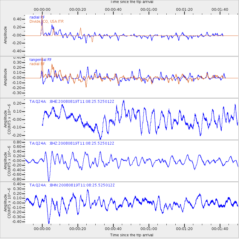
Q24A Divide, CO, USA - Earthquake Result Viewer
*The percent match for this event was below the threshold and hence no stack was calculated.
| Earthquake location: |
Easter Island Region |
| Earthquake latitude/longitude: |
-28.5/-112.8 |
| Earthquake time(UTC): |
2008/08/19 (232) 10:58:00 GMT |
| Earthquake Depth: |
9.0 km |
| Earthquake Magnitude: |
5.5 MB, 5.3 MS, 5.7 MW, 5.7 MW |
| Earthquake Catalog/Contributor: |
WHDF/NEIC |
|
| Network: |
TA USArray Transportable Network (new EarthScope stations) |
| Station: |
Q24A Divide, CO, USA |
| Lat/Lon: |
38.96 N/105.15 W |
| Elevation: |
2775 m |
|
| Distance: |
67.5 deg |
| Az: |
6.484 deg |
| Baz: |
187.321 deg |
| Ray Param: |
$rayparam |
*The percent match for this event was below the threshold and hence was not used in the summary stack. |
|
| Radial Match: |
58.255356 % |
| Radial Bump: |
400 |
| Transverse Match: |
39.186054 % |
| Transverse Bump: |
400 |
| SOD ConfigId: |
2504 |
| Insert Time: |
2010-03-07 05:47:19.924 +0000 |
| GWidth: |
2.5 |
| Max Bumps: |
400 |
| Tol: |
0.001 |
|
Signal To Noise
| Channel | StoN | STA | LTA |
| TA:Q24A: :BHZ:20080819T11:08:25.525012Z | 5.492029 | 3.8645837E-7 | 7.0367136E-8 |
| TA:Q24A: :BHN:20080819T11:08:25.525012Z | 3.107183 | 1.9840151E-7 | 6.385253E-8 |
| TA:Q24A: :BHE:20080819T11:08:25.525012Z | 3.0260534 | 1.9117488E-7 | 6.317631E-8 |
| Arrivals |
| Ps | |
| PpPs | |
| PsPs/PpSs | |


