You are here: Home > Network List > TA - USArray Transportable Network (new EarthScope stations) Stations List
> Station Q24A Divide, CO, USA > Earthquake Result Viewer
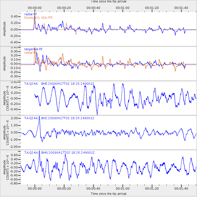
Q24A Divide, CO, USA - Earthquake Result Viewer
*The percent match for this event was below the threshold and hence no stack was calculated.
| Earthquake location: |
Near Coast Of Northern Chile |
| Earthquake latitude/longitude: |
-19.6/-70.5 |
| Earthquake time(UTC): |
2009/04/17 (107) 02:08:08 GMT |
| Earthquake Depth: |
25 km |
| Earthquake Magnitude: |
5.8 MB, 5.8 MS, 6.1 MW, 6.1 MW |
| Earthquake Catalog/Contributor: |
WHDF/NEIC |
|
| Network: |
TA USArray Transportable Network (new EarthScope stations) |
| Station: |
Q24A Divide, CO, USA |
| Lat/Lon: |
38.96 N/105.15 W |
| Elevation: |
2775 m |
|
| Distance: |
66.7 deg |
| Az: |
331.126 deg |
| Baz: |
144.267 deg |
| Ray Param: |
$rayparam |
*The percent match for this event was below the threshold and hence was not used in the summary stack. |
|
| Radial Match: |
60.867683 % |
| Radial Bump: |
400 |
| Transverse Match: |
64.773384 % |
| Transverse Bump: |
351 |
| SOD ConfigId: |
2658 |
| Insert Time: |
2010-03-07 05:47:32.920 +0000 |
| GWidth: |
2.5 |
| Max Bumps: |
400 |
| Tol: |
0.001 |
|
Signal To Noise
| Channel | StoN | STA | LTA |
| TA:Q24A: :BHZ:20090417T02:18:26.249001Z | 4.832383 | 9.421913E-7 | 1.9497448E-7 |
| TA:Q24A: :BHN:20090417T02:18:26.249001Z | 1.5146259 | 3.31718E-7 | 2.1900986E-7 |
| TA:Q24A: :BHE:20090417T02:18:26.249001Z | 1.3001163 | 3.0045445E-7 | 2.3109813E-7 |
| Arrivals |
| Ps | |
| PpPs | |
| PsPs/PpSs | |


