You are here: Home > Network List > TA - USArray Transportable Network (new EarthScope stations) Stations List
> Station Q24A Divide, CO, USA > Earthquake Result Viewer
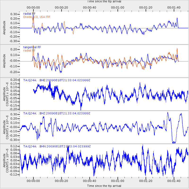
Q24A Divide, CO, USA - Earthquake Result Viewer
*The percent match for this event was below the threshold and hence no stack was calculated.
| Earthquake location: |
South Of Fiji Islands |
| Earthquake latitude/longitude: |
-26.1/-178.4 |
| Earthquake time(UTC): |
2009/08/18 (230) 21:20:47 GMT |
| Earthquake Depth: |
270 km |
| Earthquake Magnitude: |
5.5 MB, 6.3 MW, 6.3 MW |
| Earthquake Catalog/Contributor: |
WHDF/NEIC |
|
| Network: |
TA USArray Transportable Network (new EarthScope stations) |
| Station: |
Q24A Divide, CO, USA |
| Lat/Lon: |
38.96 N/105.15 W |
| Elevation: |
2775 m |
|
| Distance: |
94.1 deg |
| Az: |
48.452 deg |
| Baz: |
239.709 deg |
| Ray Param: |
$rayparam |
*The percent match for this event was below the threshold and hence was not used in the summary stack. |
|
| Radial Match: |
54.981228 % |
| Radial Bump: |
400 |
| Transverse Match: |
51.727398 % |
| Transverse Bump: |
400 |
| SOD ConfigId: |
2622 |
| Insert Time: |
2010-03-07 05:47:39.128 +0000 |
| GWidth: |
2.5 |
| Max Bumps: |
400 |
| Tol: |
0.001 |
|
Signal To Noise
| Channel | StoN | STA | LTA |
| TA:Q24A: :BHZ:20090818T21:33:04.023999Z | 1.9590064 | 1.2693178E-7 | 6.479396E-8 |
| TA:Q24A: :BHN:20090818T21:33:04.023999Z | 0.73888403 | 3.0735865E-8 | 4.1597684E-8 |
| TA:Q24A: :BHE:20090818T21:33:04.023999Z | 2.3209472 | 1.34375E-7 | 5.789662E-8 |
| Arrivals |
| Ps | |
| PpPs | |
| PsPs/PpSs | |


