You are here: Home > Network List > TS - TERRAscope (Southern California Seismic Network) Stations List
> Station PAS Pasadena, California, USA > Earthquake Result Viewer
PAS Pasadena, California, USA - Earthquake Result Viewer
| Earthquake location: |
Vanuatu Islands |
| Earthquake latitude/longitude: |
-15.3/167.4 |
| Earthquake time(UTC): |
1990/07/27 (208) 12:38:00 GMT |
| Earthquake Depth: |
133 km |
| Earthquake Magnitude: |
6.4 MB, 6.8 MS, 6.9 UNKNOWN |
| Earthquake Catalog/Contributor: |
WHDF/NEIC |
|
| Network: |
TS TERRAscope (Southern California Seismic Network) |
| Station: |
PAS Pasadena, California, USA |
| Lat/Lon: |
34.15 N/118.17 W |
| Elevation: |
295 m |
|
| Distance: |
86.1 deg |
| Az: |
53.203 deg |
| Baz: |
248.698 deg |
| Ray Param: |
0.04400411 |
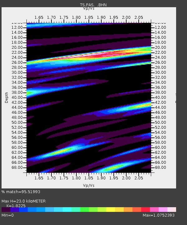
| Estimated Moho Depth: |
23.0 km |
| Estimated Crust Vp/Vs: |
1.82 |
| Assumed Crust Vp: |
6.1 km/s |
| Estimated Crust Vs: |
3.347 km/s |
| Estimated Crust Poisson's Ratio: |
0.28 |
|
| Radial Match: |
95.51993 % |
| Radial Bump: |
281 |
| Transverse Match: |
82.97253 % |
| Transverse Bump: |
400 |
| SOD ConfigId: |
16938 |
| Insert Time: |
2010-02-26 14:33:59.459 +0000 |
| GWidth: |
2.5 |
| Max Bumps: |
400 |
| Tol: |
0.001 |
|

Signal To Noise
| Channel | StoN | STA | LTA |
| TS:PAS: :BHN:19900727T12:49:55.257019Z | 5.554963 | 8.5089226E-7 | 1.5317693E-7 |
| TS:PAS: :BHE:19900727T12:49:55.257019Z | 13.686934 | 2.146003E-6 | 1.5679208E-7 |
| TS:PAS: :BHZ:19900727T12:49:55.257019Z | 37.68834 | 7.464855E-6 | 1.9806804E-7 |
| Arrivals |
| Ps | 3.2 SECOND |
| PpPs | 10 SECOND |
| PsPs/PpSs | 14 SECOND |


