You are here: Home > Network List > CI - Caltech Regional Seismic Network Stations List
> Station FUR Furnace Creek, CA, USA > Earthquake Result Viewer
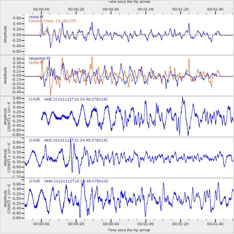
FUR Furnace Creek, CA, USA - Earthquake Result Viewer
*The percent match for this event was below the threshold and hence no stack was calculated.
| Earthquake location: |
Near Coast Of Guatemala |
| Earthquake latitude/longitude: |
13.7/-91.0 |
| Earthquake time(UTC): |
2019/11/13 (317) 16:28:54 GMT |
| Earthquake Depth: |
61 km |
| Earthquake Magnitude: |
5.5 Mww |
| Earthquake Catalog/Contributor: |
NEIC PDE/us |
|
| Network: |
CI Caltech Regional Seismic Network |
| Station: |
FUR Furnace Creek, CA, USA |
| Lat/Lon: |
36.47 N/116.86 W |
| Elevation: |
-37.0 m |
|
| Distance: |
32.5 deg |
| Az: |
318.99 deg |
| Baz: |
127.697 deg |
| Ray Param: |
$rayparam |
*The percent match for this event was below the threshold and hence was not used in the summary stack. |
|
| Radial Match: |
72.562294 % |
| Radial Bump: |
400 |
| Transverse Match: |
75.10978 % |
| Transverse Bump: |
400 |
| SOD ConfigId: |
19951751 |
| Insert Time: |
2019-11-27 16:41:27.465 +0000 |
| GWidth: |
2.5 |
| Max Bumps: |
400 |
| Tol: |
0.001 |
|
Signal To Noise
| Channel | StoN | STA | LTA |
| CI:FUR: :HHZ:20191113T16:34:48.678014Z | 1.722578 | 3.4685328E-7 | 2.0135708E-7 |
| CI:FUR: :HHN:20191113T16:34:48.678014Z | 1.5697497 | 3.247318E-7 | 2.068685E-7 |
| CI:FUR: :HHE:20191113T16:34:48.678014Z | 1.7411155 | 3.2192523E-7 | 1.8489597E-7 |
| Arrivals |
| Ps | |
| PpPs | |
| PsPs/PpSs | |


