You are here: Home > Network List > IU - Global Seismograph Network (GSN - IRIS/USGS) Stations List
> Station JOHN Johnston Island, USA > Earthquake Result Viewer
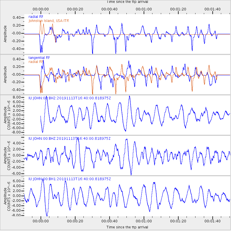
JOHN Johnston Island, USA - Earthquake Result Viewer
*The percent match for this event was below the threshold and hence no stack was calculated.
| Earthquake location: |
Near Coast Of Guatemala |
| Earthquake latitude/longitude: |
13.7/-91.0 |
| Earthquake time(UTC): |
2019/11/13 (317) 16:28:54 GMT |
| Earthquake Depth: |
61 km |
| Earthquake Magnitude: |
5.5 Mww |
| Earthquake Catalog/Contributor: |
NEIC PDE/us |
|
| Network: |
IU Global Seismograph Network (GSN - IRIS/USGS) |
| Station: |
JOHN Johnston Island, USA |
| Lat/Lon: |
16.73 N/169.53 W |
| Elevation: |
2.0 m |
|
| Distance: |
75.4 deg |
| Az: |
283.963 deg |
| Baz: |
79.888 deg |
| Ray Param: |
$rayparam |
*The percent match for this event was below the threshold and hence was not used in the summary stack. |
|
| Radial Match: |
51.93858 % |
| Radial Bump: |
364 |
| Transverse Match: |
50.473953 % |
| Transverse Bump: |
400 |
| SOD ConfigId: |
19951751 |
| Insert Time: |
2019-11-27 16:42:51.765 +0000 |
| GWidth: |
2.5 |
| Max Bumps: |
400 |
| Tol: |
0.001 |
|
Signal To Noise
| Channel | StoN | STA | LTA |
| IU:JOHN:00:BHZ:20191113T16:40:00.818975Z | 1.375816 | 1.7520591E-6 | 1.273469E-6 |
| IU:JOHN:00:BH1:20191113T16:40:00.818975Z | 2.5323586 | 4.9574774E-6 | 1.957652E-6 |
| IU:JOHN:00:BH2:20191113T16:40:00.818975Z | 1.0576578 | 3.6692443E-6 | 3.4692166E-6 |
| Arrivals |
| Ps | |
| PpPs | |
| PsPs/PpSs | |


