You are here: Home > Network List > TS - TERRAscope (Southern California Seismic Network) Stations List
> Station PAS Pasadena, California, USA > Earthquake Result Viewer
PAS Pasadena, California, USA - Earthquake Result Viewer
| Earthquake location: |
Southern Bolivia |
| Earthquake latitude/longitude: |
-19.3/-66.6 |
| Earthquake time(UTC): |
1990/10/10 (283) 01:00:06 GMT |
| Earthquake Depth: |
271 km |
| Earthquake Magnitude: |
5.8 MB, 6.4 UNKNOWN |
| Earthquake Catalog/Contributor: |
WHDF/NEIC |
|
| Network: |
TS TERRAscope (Southern California Seismic Network) |
| Station: |
PAS Pasadena, California, USA |
| Lat/Lon: |
34.15 N/118.17 W |
| Elevation: |
295 m |
|
| Distance: |
72.4 deg |
| Az: |
316.997 deg |
| Baz: |
129.055 deg |
| Ray Param: |
0.05291975 |
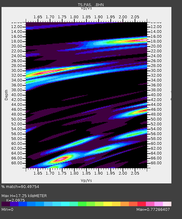
| Estimated Moho Depth: |
17.25 km |
| Estimated Crust Vp/Vs: |
2.10 |
| Assumed Crust Vp: |
6.1 km/s |
| Estimated Crust Vs: |
2.908 km/s |
| Estimated Crust Poisson's Ratio: |
0.35 |
|
| Radial Match: |
90.49754 % |
| Radial Bump: |
297 |
| Transverse Match: |
74.18648 % |
| Transverse Bump: |
400 |
| SOD ConfigId: |
16938 |
| Insert Time: |
2010-02-26 14:34:03.548 +0000 |
| GWidth: |
2.5 |
| Max Bumps: |
400 |
| Tol: |
0.001 |
|
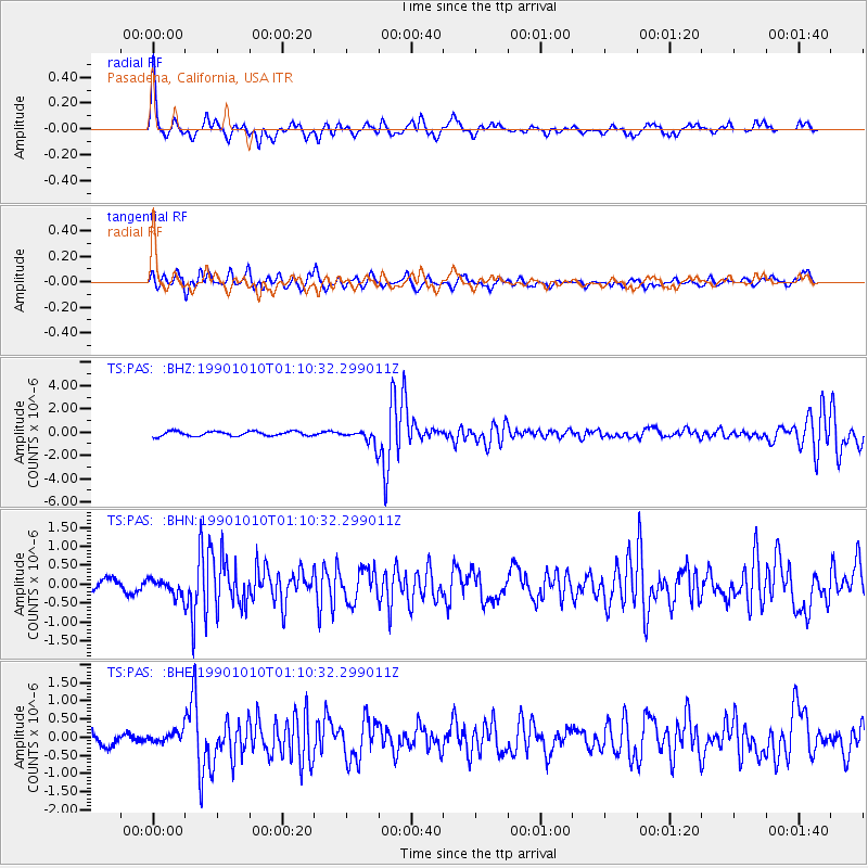
Signal To Noise
| Channel | StoN | STA | LTA |
| TS:PAS: :BHN:19901010T01:10:32.299011Z | 1.3271148 | 2.2750334E-7 | 1.7142702E-7 |
| TS:PAS: :BHE:19901010T01:10:32.299011Z | 1.0787095 | 1.7058319E-7 | 1.5813636E-7 |
| TS:PAS: :BHZ:19901010T01:10:32.299011Z | 3.4104285 | 6.7422525E-7 | 1.9769517E-7 |
| Arrivals |
| Ps | 3.2 SECOND |
| PpPs | 8.5 SECOND |
| PsPs/PpSs | 12 SECOND |


