You are here: Home > Network List > TA - USArray Transportable Network (new EarthScope stations) Stations List
> Station C16K Lisburne Hills, AK, USA > Earthquake Result Viewer
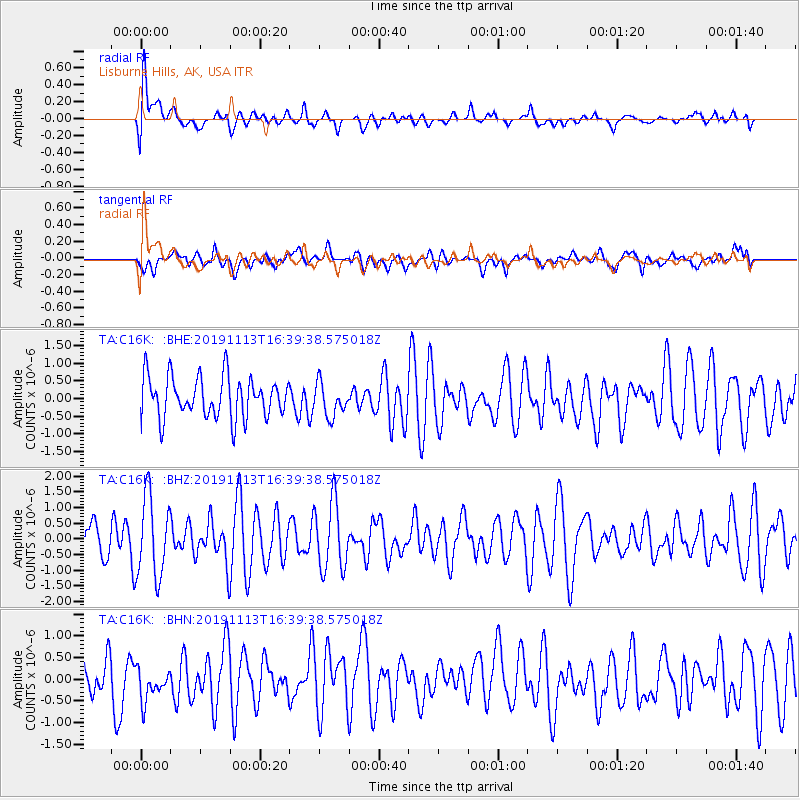
C16K Lisburne Hills, AK, USA - Earthquake Result Viewer
*The percent match for this event was below the threshold and hence no stack was calculated.
| Earthquake location: |
Near Coast Of Guatemala |
| Earthquake latitude/longitude: |
13.7/-91.0 |
| Earthquake time(UTC): |
2019/11/13 (317) 16:28:54 GMT |
| Earthquake Depth: |
61 km |
| Earthquake Magnitude: |
5.5 Mww |
| Earthquake Catalog/Contributor: |
NEIC PDE/us |
|
| Network: |
TA USArray Transportable Network (new EarthScope stations) |
| Station: |
C16K Lisburne Hills, AK, USA |
| Lat/Lon: |
68.27 N/165.34 W |
| Elevation: |
102 m |
|
| Distance: |
71.6 deg |
| Az: |
337.8 deg |
| Baz: |
99.429 deg |
| Ray Param: |
$rayparam |
*The percent match for this event was below the threshold and hence was not used in the summary stack. |
|
| Radial Match: |
65.791664 % |
| Radial Bump: |
400 |
| Transverse Match: |
55.06339 % |
| Transverse Bump: |
400 |
| SOD ConfigId: |
19951751 |
| Insert Time: |
2019-11-27 16:44:01.153 +0000 |
| GWidth: |
2.5 |
| Max Bumps: |
400 |
| Tol: |
0.001 |
|
Signal To Noise
| Channel | StoN | STA | LTA |
| TA:C16K: :BHZ:20191113T16:39:38.575018Z | 2.3266869 | 1.2774694E-6 | 5.4905087E-7 |
| TA:C16K: :BHN:20191113T16:39:38.575018Z | 0.7722331 | 4.080227E-7 | 5.2836725E-7 |
| TA:C16K: :BHE:20191113T16:39:38.575018Z | 0.8083716 | 4.6514492E-7 | 5.754098E-7 |
| Arrivals |
| Ps | |
| PpPs | |
| PsPs/PpSs | |


