You are here: Home > Network List > TA - USArray Transportable Network (new EarthScope stations) Stations List
> Station K15K Wolf Creek Mountain, AK, USA > Earthquake Result Viewer
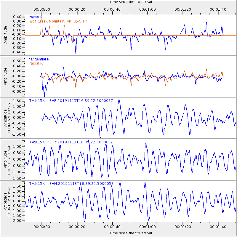
K15K Wolf Creek Mountain, AK, USA - Earthquake Result Viewer
*The percent match for this event was below the threshold and hence no stack was calculated.
| Earthquake location: |
Near Coast Of Guatemala |
| Earthquake latitude/longitude: |
13.7/-91.0 |
| Earthquake time(UTC): |
2019/11/13 (317) 16:28:54 GMT |
| Earthquake Depth: |
61 km |
| Earthquake Magnitude: |
5.5 Mww |
| Earthquake Catalog/Contributor: |
NEIC PDE/us |
|
| Network: |
TA USArray Transportable Network (new EarthScope stations) |
| Station: |
K15K Wolf Creek Mountain, AK, USA |
| Lat/Lon: |
62.29 N/161.53 W |
| Elevation: |
346 m |
|
| Distance: |
69.0 deg |
| Az: |
331.823 deg |
| Baz: |
100.876 deg |
| Ray Param: |
$rayparam |
*The percent match for this event was below the threshold and hence was not used in the summary stack. |
|
| Radial Match: |
44.127266 % |
| Radial Bump: |
400 |
| Transverse Match: |
68.37889 % |
| Transverse Bump: |
400 |
| SOD ConfigId: |
19951751 |
| Insert Time: |
2019-11-27 16:44:14.756 +0000 |
| GWidth: |
2.5 |
| Max Bumps: |
400 |
| Tol: |
0.001 |
|
Signal To Noise
| Channel | StoN | STA | LTA |
| TA:K15K: :BHZ:20191113T16:39:22.500005Z | 1.4542217 | 7.962851E-7 | 5.4756794E-7 |
| TA:K15K: :BHN:20191113T16:39:22.500005Z | 1.4143308 | 4.771472E-7 | 3.3736606E-7 |
| TA:K15K: :BHE:20191113T16:39:22.500005Z | 3.4151297 | 9.3531037E-7 | 2.738726E-7 |
| Arrivals |
| Ps | |
| PpPs | |
| PsPs/PpSs | |


