You are here: Home > Network List > TA - USArray Transportable Network (new EarthScope stations) Stations List
> Station M31M Drury Creek, Yukon, CA > Earthquake Result Viewer
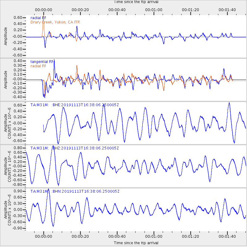
M31M Drury Creek, Yukon, CA - Earthquake Result Viewer
*The percent match for this event was below the threshold and hence no stack was calculated.
| Earthquake location: |
Near Coast Of Guatemala |
| Earthquake latitude/longitude: |
13.7/-91.0 |
| Earthquake time(UTC): |
2019/11/13 (317) 16:28:54 GMT |
| Earthquake Depth: |
61 km |
| Earthquake Magnitude: |
5.5 Mww |
| Earthquake Catalog/Contributor: |
NEIC PDE/us |
|
| Network: |
TA USArray Transportable Network (new EarthScope stations) |
| Station: |
M31M Drury Creek, Yukon, CA |
| Lat/Lon: |
62.20 N/134.39 W |
| Elevation: |
639 m |
|
| Distance: |
57.4 deg |
| Az: |
337.516 deg |
| Baz: |
127.538 deg |
| Ray Param: |
$rayparam |
*The percent match for this event was below the threshold and hence was not used in the summary stack. |
|
| Radial Match: |
70.30899 % |
| Radial Bump: |
400 |
| Transverse Match: |
68.80487 % |
| Transverse Bump: |
400 |
| SOD ConfigId: |
19951751 |
| Insert Time: |
2019-11-27 16:44:18.637 +0000 |
| GWidth: |
2.5 |
| Max Bumps: |
400 |
| Tol: |
0.001 |
|
Signal To Noise
| Channel | StoN | STA | LTA |
| TA:M31M: :BHZ:20191113T16:38:06.250005Z | 1.1348593 | 4.6003402E-7 | 4.0536654E-7 |
| TA:M31M: :BHN:20191113T16:38:06.250005Z | 2.2733123 | 6.0209953E-7 | 2.648556E-7 |
| TA:M31M: :BHE:20191113T16:38:06.250005Z | 1.4805255 | 4.0031193E-7 | 2.7038502E-7 |
| Arrivals |
| Ps | |
| PpPs | |
| PsPs/PpSs | |


