You are here: Home > Network List > TS - TERRAscope (Southern California Seismic Network) Stations List
> Station PAS Pasadena, California, USA > Earthquake Result Viewer
PAS Pasadena, California, USA - Earthquake Result Viewer
| Earthquake location: |
Peru-Brazil Border Region |
| Earthquake latitude/longitude: |
-11.0/-70.8 |
| Earthquake time(UTC): |
1990/10/17 (290) 14:30:14 GMT |
| Earthquake Depth: |
624 km |
| Earthquake Magnitude: |
6.7 MB, 6.8 UNKNOWN |
| Earthquake Catalog/Contributor: |
WHDF/NEIC |
|
| Network: |
TS TERRAscope (Southern California Seismic Network) |
| Station: |
PAS Pasadena, California, USA |
| Lat/Lon: |
34.15 N/118.17 W |
| Elevation: |
295 m |
|
| Distance: |
63.5 deg |
| Az: |
317.019 deg |
| Baz: |
126.179 deg |
| Ray Param: |
0.057086367 |
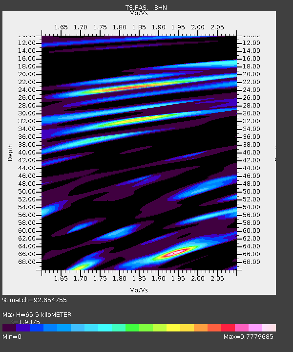
| Estimated Moho Depth: |
65.5 km |
| Estimated Crust Vp/Vs: |
1.94 |
| Assumed Crust Vp: |
6.1 km/s |
| Estimated Crust Vs: |
3.148 km/s |
| Estimated Crust Poisson's Ratio: |
0.32 |
|
| Radial Match: |
92.654755 % |
| Radial Bump: |
400 |
| Transverse Match: |
85.92081 % |
| Transverse Bump: |
400 |
| SOD ConfigId: |
16938 |
| Insert Time: |
2010-02-26 14:34:04.963 +0000 |
| GWidth: |
2.5 |
| Max Bumps: |
400 |
| Tol: |
0.001 |
|
Signal To Noise
| Channel | StoN | STA | LTA |
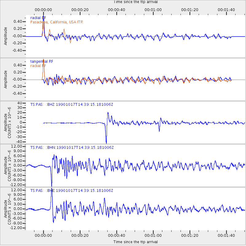
| TS:PAS: :BHN:19901017T14:39:15.181006Z | 9.79732 | 3.3613517E-6 | 3.4308889E-7 |
| TS:PAS: :BHE:19901017T14:39:15.181006Z | 13.289973 | 4.2456595E-6 | 3.1946337E-7 |
| TS:PAS: :BHZ:19901017T14:39:15.181006Z | 49.30701 | 1.2032091E-5 | 2.4402394E-7 |
| Arrivals |
| Ps | 10 SECOND |
| PpPs | 31 SECOND |
| PsPs/PpSs | 41 SECOND |


