You are here: Home > Network List > TA - USArray Transportable Network (new EarthScope stations) Stations List
> Station Q24A Divide, CO, USA > Earthquake Result Viewer
Q24A Divide, CO, USA - Earthquake Result Viewer
*The percent match for this event was below the threshold and hence no stack was calculated.
| Earthquake location: |
Kuril Islands |
| Earthquake latitude/longitude: |
46.0/151.4 |
| Earthquake time(UTC): |
2009/04/18 (108) 19:17:58 GMT |
| Earthquake Depth: |
35 km |
| Earthquake Magnitude: |
6.3 MB, 6.3 MS, 6.6 MW, 6.4 MW |
| Earthquake Catalog/Contributor: |
WHDF/NEIC |
|
| Network: |
TA USArray Transportable Network (new EarthScope stations) |
| Station: |
Q24A Divide, CO, USA |
| Lat/Lon: |
38.96 N/105.15 W |
| Elevation: |
2775 m |
|
| Distance: |
71.2 deg |
| Az: |
53.25 deg |
| Baz: |
314.255 deg |
| Ray Param: |
$rayparam |
*The percent match for this event was below the threshold and hence was not used in the summary stack. |
|
| Radial Match: |
55.606457 % |
| Radial Bump: |
400 |
| Transverse Match: |
84.663185 % |
| Transverse Bump: |
400 |
| SOD ConfigId: |
2760 |
| Insert Time: |
2010-03-07 05:49:04.622 +0000 |
| GWidth: |
2.5 |
| Max Bumps: |
400 |
| Tol: |
0.001 |
|
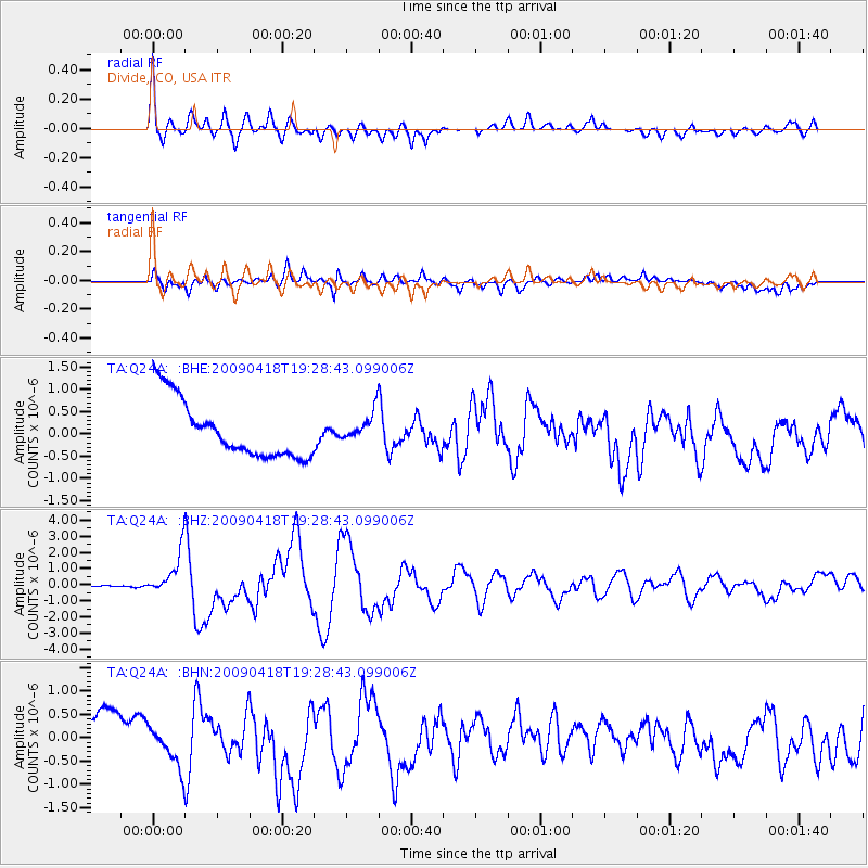
Signal To Noise
| Channel | StoN | STA | LTA |
| TA:Q24A: :BHZ:20090418T19:28:43.099006Z | 12.639868 | 1.3412392E-6 | 1.0611181E-7 |
| TA:Q24A: :BHN:20090418T19:28:43.099006Z | 0.6605185 | 3.9006005E-7 | 5.905361E-7 |
| TA:Q24A: :BHE:20090418T19:28:43.099006Z | 0.50748867 | 3.2647458E-7 | 6.43314E-7 |
| Arrivals |
| Ps | |
| PpPs | |
| PsPs/PpSs | |


