You are here: Home > Network List > AK - Alaska Regional Network Stations List
> Station FALS False Pass > Earthquake Result Viewer
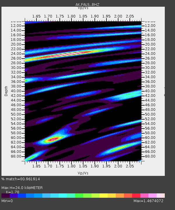
FALS False Pass - Earthquake Result Viewer
| Earthquake location: |
Northern Molucca Sea |
| Earthquake latitude/longitude: |
1.5/126.4 |
| Earthquake time(UTC): |
2019/11/14 (318) 16:17:42 GMT |
| Earthquake Depth: |
62 km |
| Earthquake Magnitude: |
7.4 Mi |
| Earthquake Catalog/Contributor: |
NEIC PDE/at |
|
| Network: |
AK Alaska Regional Network |
| Station: |
FALS False Pass |
| Lat/Lon: |
54.86 N/163.42 W |
| Elevation: |
46 m |
|
| Distance: |
77.5 deg |
| Az: |
33.867 deg |
| Baz: |
254.464 deg |
| Ray Param: |
0.050184082 |
| Estimated Moho Depth: |
24.0 km |
| Estimated Crust Vp/Vs: |
1.78 |
| Assumed Crust Vp: |
5.989 km/s |
| Estimated Crust Vs: |
3.365 km/s |
| Estimated Crust Poisson's Ratio: |
0.27 |
|
| Radial Match: |
80.961914 % |
| Radial Bump: |
400 |
| Transverse Match: |
65.57864 % |
| Transverse Bump: |
400 |
| SOD ConfigId: |
19951751 |
| Insert Time: |
2019-11-28 16:23:30.145 +0000 |
| GWidth: |
2.5 |
| Max Bumps: |
400 |
| Tol: |
0.001 |
|

Signal To Noise
| Channel | StoN | STA | LTA |
| AK:FALS: :BHZ:20191114T16:28:59.708008Z | 3.7373893 | 6.8202803E-6 | 1.8248782E-6 |
| AK:FALS: :BHN:20191114T16:28:59.708008Z | 0.8751772 | 2.675561E-6 | 3.057165E-6 |
| AK:FALS: :BHE:20191114T16:28:59.708008Z | 1.1735386 | 2.6082428E-6 | 2.2225454E-6 |
| Arrivals |
| Ps | 3.2 SECOND |
| PpPs | 11 SECOND |
| PsPs/PpSs | 14 SECOND |


