You are here: Home > Network List > TA - USArray Transportable Network (new EarthScope stations) Stations List
> Station Q24A Divide, CO, USA > Earthquake Result Viewer
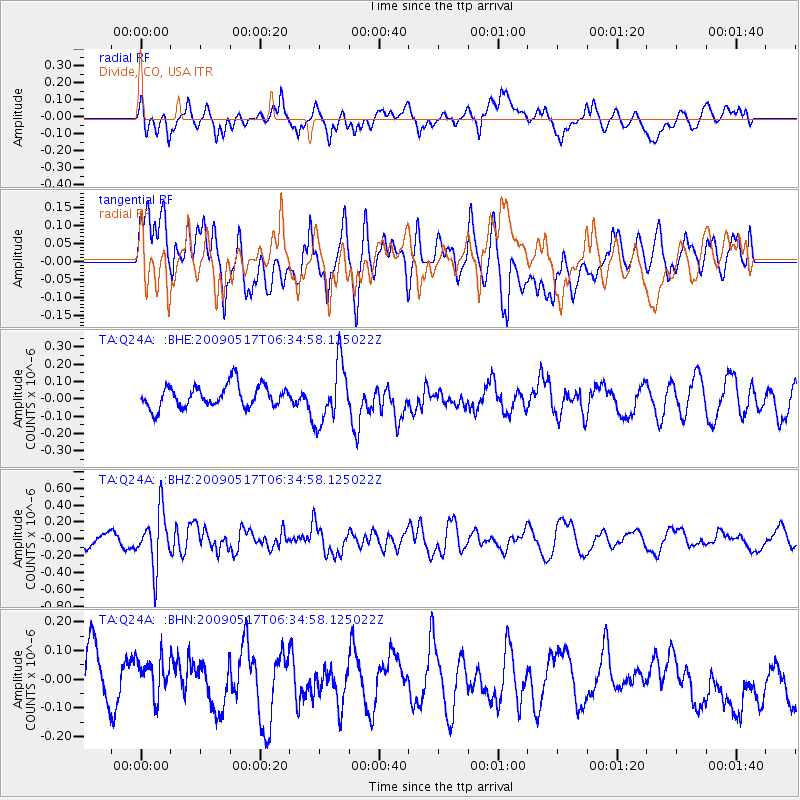
Q24A Divide, CO, USA - Earthquake Result Viewer
*The percent match for this event was below the threshold and hence no stack was calculated.
| Earthquake location: |
Tonga Islands |
| Earthquake latitude/longitude: |
-16.8/-173.5 |
| Earthquake time(UTC): |
2009/05/17 (137) 06:23:03 GMT |
| Earthquake Depth: |
67 km |
| Earthquake Magnitude: |
5.5 MB, 5.6 MW, 5.6 MW |
| Earthquake Catalog/Contributor: |
WHDF/NEIC |
|
| Network: |
TA USArray Transportable Network (new EarthScope stations) |
| Station: |
Q24A Divide, CO, USA |
| Lat/Lon: |
38.96 N/105.15 W |
| Elevation: |
2775 m |
|
| Distance: |
84.5 deg |
| Az: |
46.709 deg |
| Baz: |
243.405 deg |
| Ray Param: |
$rayparam |
*The percent match for this event was below the threshold and hence was not used in the summary stack. |
|
| Radial Match: |
54.563637 % |
| Radial Bump: |
400 |
| Transverse Match: |
62.000156 % |
| Transverse Bump: |
400 |
| SOD ConfigId: |
2760 |
| Insert Time: |
2010-03-07 05:49:12.471 +0000 |
| GWidth: |
2.5 |
| Max Bumps: |
400 |
| Tol: |
0.001 |
|
Signal To Noise
| Channel | StoN | STA | LTA |
| TA:Q24A: :BHZ:20090517T06:34:58.125022Z | 4.213646 | 3.25883E-7 | 7.733991E-8 |
| TA:Q24A: :BHN:20090517T06:34:58.125022Z | 0.97743577 | 6.869914E-8 | 7.028507E-8 |
| TA:Q24A: :BHE:20090517T06:34:58.125022Z | 2.6749756 | 1.7035414E-7 | 6.368437E-8 |
| Arrivals |
| Ps | |
| PpPs | |
| PsPs/PpSs | |


