You are here: Home > Network List > AK - Alaska Regional Network Stations List
> Station L22K Petersville, AK, USA > Earthquake Result Viewer
L22K Petersville, AK, USA - Earthquake Result Viewer
| Earthquake location: |
Northern Molucca Sea |
| Earthquake latitude/longitude: |
1.5/126.4 |
| Earthquake time(UTC): |
2019/11/14 (318) 16:17:42 GMT |
| Earthquake Depth: |
62 km |
| Earthquake Magnitude: |
7.4 Mi |
| Earthquake Catalog/Contributor: |
NEIC PDE/at |
|
| Network: |
AK Alaska Regional Network |
| Station: |
L22K Petersville, AK, USA |
| Lat/Lon: |
62.53 N/150.77 W |
| Elevation: |
817 m |
|
| Distance: |
85.4 deg |
| Az: |
27.495 deg |
| Baz: |
264.329 deg |
| Ray Param: |
0.04470547 |
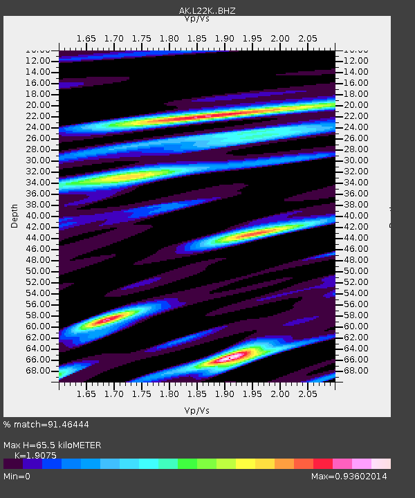
| Estimated Moho Depth: |
65.5 km |
| Estimated Crust Vp/Vs: |
1.91 |
| Assumed Crust Vp: |
6.438 km/s |
| Estimated Crust Vs: |
3.375 km/s |
| Estimated Crust Poisson's Ratio: |
0.31 |
|
| Radial Match: |
91.46444 % |
| Radial Bump: |
400 |
| Transverse Match: |
82.31498 % |
| Transverse Bump: |
400 |
| SOD ConfigId: |
19951751 |
| Insert Time: |
2019-11-28 16:24:08.306 +0000 |
| GWidth: |
2.5 |
| Max Bumps: |
400 |
| Tol: |
0.001 |
|

Signal To Noise
| Channel | StoN | STA | LTA |
| AK:L22K: :BHZ:20191114T16:29:41.320007Z | 9.184099 | 3.2582843E-6 | 3.547745E-7 |
| AK:L22K: :BHN:20191114T16:29:41.320007Z | 1.0346831 | 6.220127E-7 | 6.011625E-7 |
| AK:L22K: :BHE:20191114T16:29:41.320007Z | 3.05185 | 1.3870131E-6 | 4.5448272E-7 |
| Arrivals |
| Ps | 9.4 SECOND |
| PpPs | 29 SECOND |
| PsPs/PpSs | 38 SECOND |


