You are here: Home > Network List > AV - Alaska Volcano Observatory Stations List
> Station AUJA Augustine Junction, Augustine Volcano, Alaska > Earthquake Result Viewer
AUJA Augustine Junction, Augustine Volcano, Alaska - Earthquake Result Viewer
| Earthquake location: |
Northern Molucca Sea |
| Earthquake latitude/longitude: |
1.5/126.4 |
| Earthquake time(UTC): |
2019/11/14 (318) 16:17:42 GMT |
| Earthquake Depth: |
62 km |
| Earthquake Magnitude: |
7.4 Mi |
| Earthquake Catalog/Contributor: |
NEIC PDE/at |
|
| Network: |
AV Alaska Volcano Observatory |
| Station: |
AUJA Augustine Junction, Augustine Volcano, Alaska |
| Lat/Lon: |
59.34 N/153.42 W |
| Elevation: |
376 m |
|
| Distance: |
83.7 deg |
| Az: |
30.533 deg |
| Baz: |
262.303 deg |
| Ray Param: |
0.04588339 |
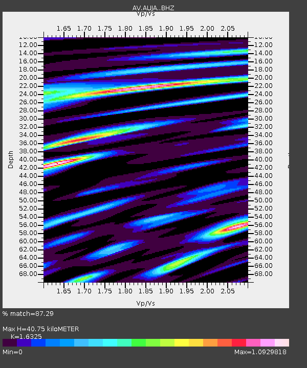
| Estimated Moho Depth: |
40.75 km |
| Estimated Crust Vp/Vs: |
1.63 |
| Assumed Crust Vp: |
5.989 km/s |
| Estimated Crust Vs: |
3.669 km/s |
| Estimated Crust Poisson's Ratio: |
0.20 |
|
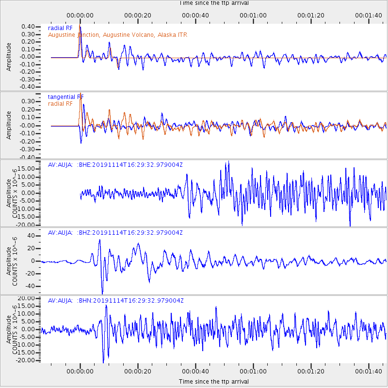
| Radial Match: |
87.29 % |
| Radial Bump: |
400 |
| Transverse Match: |
89.49069 % |
| Transverse Bump: |
400 |
| SOD ConfigId: |
19951751 |
| Insert Time: |
2019-11-28 16:24:32.688 +0000 |
| GWidth: |
2.5 |
| Max Bumps: |
400 |
| Tol: |
0.001 |
|
Signal To Noise
| Channel | StoN | STA | LTA |
| AV:AUJA: :BHZ:20191114T16:29:32.979004Z | 3.4682386 | 4.6345694E-6 | 1.3362891E-6 |
| AV:AUJA: :BHN:20191114T16:29:32.979004Z | 1.1927037 | 1.5562413E-6 | 1.3048012E-6 |
| AV:AUJA: :BHE:20191114T16:29:32.979004Z | 1.2913779 | 2.3281602E-6 | 1.8028497E-6 |
| Arrivals |
| Ps | 4.4 SECOND |
| PpPs | 17 SECOND |
| PsPs/PpSs | 22 SECOND |


