You are here: Home > Network List > TA - USArray Transportable Network (new EarthScope stations) Stations List
> Station X27A F and S Farms, Texico, NM, USA > Earthquake Result Viewer
X27A F and S Farms, Texico, NM, USA - Earthquake Result Viewer
| Earthquake location: |
Vanuatu Islands |
| Earthquake latitude/longitude: |
-13.5/167.0 |
| Earthquake time(UTC): |
2008/09/08 (252) 18:52:06 GMT |
| Earthquake Depth: |
110 km |
| Earthquake Magnitude: |
6.4 MB, 6.9 MW, 6.9 MW |
| Earthquake Catalog/Contributor: |
WHDF/NEIC |
|
| Network: |
TA USArray Transportable Network (new EarthScope stations) |
| Station: |
X27A F and S Farms, Texico, NM, USA |
| Lat/Lon: |
34.65 N/103.10 W |
| Elevation: |
1304 m |
|
| Distance: |
97.5 deg |
| Az: |
56.258 deg |
| Baz: |
258.841 deg |
| Ray Param: |
0.04010892 |
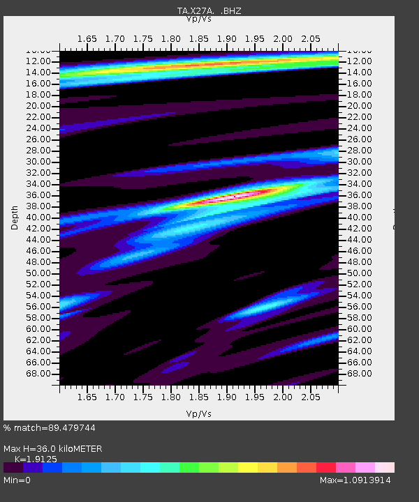
| Estimated Moho Depth: |
36.0 km |
| Estimated Crust Vp/Vs: |
1.91 |
| Assumed Crust Vp: |
6.242 km/s |
| Estimated Crust Vs: |
3.264 km/s |
| Estimated Crust Poisson's Ratio: |
0.31 |
|
| Radial Match: |
89.479744 % |
| Radial Bump: |
400 |
| Transverse Match: |
56.63773 % |
| Transverse Bump: |
400 |
| SOD ConfigId: |
2560 |
| Insert Time: |
2010-03-07 05:49:37.297 +0000 |
| GWidth: |
2.5 |
| Max Bumps: |
400 |
| Tol: |
0.001 |
|

Signal To Noise
| Channel | StoN | STA | LTA |
| TA:X27A: :BHZ:20080908T19:04:57.000029Z | 12.363104 | 1.5009618E-6 | 1.2140656E-7 |
| TA:X27A: :BHN:20080908T19:04:57.000029Z | 1.9515258 | 2.5925607E-7 | 1.3284789E-7 |
| TA:X27A: :BHE:20080908T19:04:57.000029Z | 3.0085614 | 3.885163E-7 | 1.291369E-7 |
| Arrivals |
| Ps | 5.4 SECOND |
| PpPs | 17 SECOND |
| PsPs/PpSs | 22 SECOND |


