You are here: Home > Network List > AV - Alaska Volcano Observatory Stations List
> Station ADAG Mount Adagdak, Regional Station, Alaska > Earthquake Result Viewer
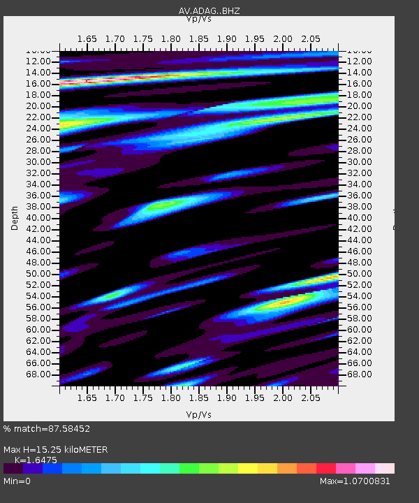
ADAG Mount Adagdak, Regional Station, Alaska - Earthquake Result Viewer
| Earthquake location: |
Northern Molucca Sea |
| Earthquake latitude/longitude: |
1.5/126.4 |
| Earthquake time(UTC): |
2019/11/14 (318) 16:17:42 GMT |
| Earthquake Depth: |
62 km |
| Earthquake Magnitude: |
7.4 Mi |
| Earthquake Catalog/Contributor: |
NEIC PDE/at |
|
| Network: |
AV Alaska Volcano Observatory |
| Station: |
ADAG Mount Adagdak, Regional Station, Alaska |
| Lat/Lon: |
51.98 N/176.60 W |
| Elevation: |
281 m |
|
| Distance: |
69.1 deg |
| Az: |
33.734 deg |
| Baz: |
243.842 deg |
| Ray Param: |
0.05575237 |
| Estimated Moho Depth: |
15.25 km |
| Estimated Crust Vp/Vs: |
1.65 |
| Assumed Crust Vp: |
5.88 km/s |
| Estimated Crust Vs: |
3.569 km/s |
| Estimated Crust Poisson's Ratio: |
0.21 |
|
| Radial Match: |
87.58452 % |
| Radial Bump: |
400 |
| Transverse Match: |
81.30551 % |
| Transverse Bump: |
400 |
| SOD ConfigId: |
19951751 |
| Insert Time: |
2019-11-28 16:24:50.971 +0000 |
| GWidth: |
2.5 |
| Max Bumps: |
400 |
| Tol: |
0.001 |
|

Signal To Noise
| Channel | StoN | STA | LTA |
| AV:ADAG: :BHZ:20191114T16:28:10.499023Z | 2.9313796 | 3.1166867E-6 | 1.063215E-6 |
| AV:ADAG: :BHN:20191114T16:28:10.499023Z | 1.4821856 | 2.3451462E-6 | 1.5822216E-6 |
| AV:ADAG: :BHE:20191114T16:28:10.499023Z | 0.6344756 | 9.751072E-7 | 1.5368712E-6 |
| Arrivals |
| Ps | 1.7 SECOND |
| PpPs | 6.6 SECOND |
| PsPs/PpSs | 8.4 SECOND |


