You are here: Home > Network List > AV - Alaska Volcano Observatory Stations List
> Station GSIG Igitkin Island, Great Sitkin Volcano, Alaska > Earthquake Result Viewer
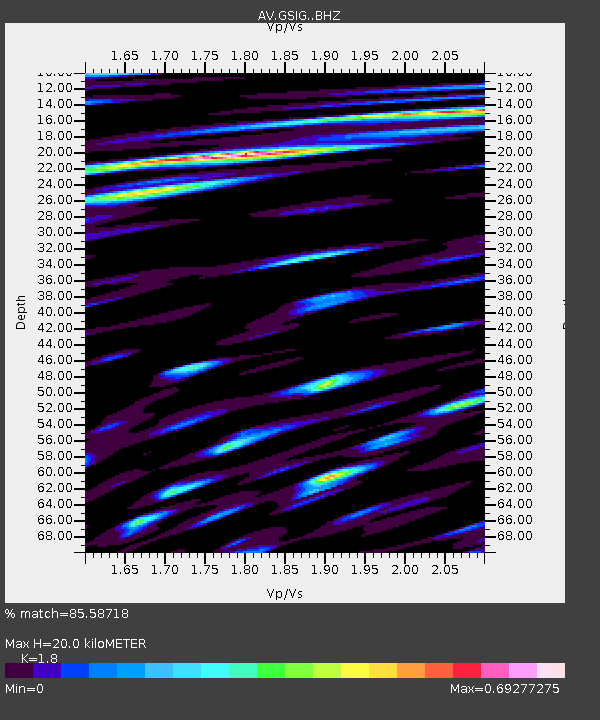
GSIG Igitkin Island, Great Sitkin Volcano, Alaska - Earthquake Result Viewer
| Earthquake location: |
Northern Molucca Sea |
| Earthquake latitude/longitude: |
1.5/126.4 |
| Earthquake time(UTC): |
2019/11/14 (318) 16:17:42 GMT |
| Earthquake Depth: |
62 km |
| Earthquake Magnitude: |
7.4 Mi |
| Earthquake Catalog/Contributor: |
NEIC PDE/at |
|
| Network: |
AV Alaska Volcano Observatory |
| Station: |
GSIG Igitkin Island, Great Sitkin Volcano, Alaska |
| Lat/Lon: |
51.99 N/175.93 W |
| Elevation: |
407 m |
|
| Distance: |
69.4 deg |
| Az: |
33.924 deg |
| Baz: |
244.44 deg |
| Ray Param: |
0.055502225 |
| Estimated Moho Depth: |
20.0 km |
| Estimated Crust Vp/Vs: |
1.80 |
| Assumed Crust Vp: |
3.943 km/s |
| Estimated Crust Vs: |
2.191 km/s |
| Estimated Crust Poisson's Ratio: |
0.28 |
|
| Radial Match: |
85.58718 % |
| Radial Bump: |
400 |
| Transverse Match: |
76.05005 % |
| Transverse Bump: |
400 |
| SOD ConfigId: |
19951751 |
| Insert Time: |
2019-11-28 16:24:52.047 +0000 |
| GWidth: |
2.5 |
| Max Bumps: |
400 |
| Tol: |
0.001 |
|

Signal To Noise
| Channel | StoN | STA | LTA |
| AV:GSIG: :BHZ:20191114T16:28:12.820007Z | 3.4876683 | 2.7524072E-6 | 7.891826E-7 |
| AV:GSIG: :BHN:20191114T16:28:12.820007Z | 1.1654938 | 1.284279E-6 | 1.1019183E-6 |
| AV:GSIG: :BHE:20191114T16:28:12.820007Z | 1.3054817 | 1.18629E-6 | 9.08699E-7 |
| Arrivals |
| Ps | 4.1 SECOND |
| PpPs | 14 SECOND |
| PsPs/PpSs | 18 SECOND |


