You are here: Home > Network List > AV - Alaska Volcano Observatory Stations List
> Station TAPA Point Aries, Tanaga Volcano, Alaska > Earthquake Result Viewer
TAPA Point Aries, Tanaga Volcano, Alaska - Earthquake Result Viewer
| Earthquake location: |
Northern Molucca Sea |
| Earthquake latitude/longitude: |
1.5/126.4 |
| Earthquake time(UTC): |
2019/11/14 (318) 16:17:42 GMT |
| Earthquake Depth: |
62 km |
| Earthquake Magnitude: |
7.4 Mi |
| Earthquake Catalog/Contributor: |
NEIC PDE/at |
|
| Network: |
AV Alaska Volcano Observatory |
| Station: |
TAPA Point Aries, Tanaga Volcano, Alaska |
| Lat/Lon: |
51.81 N/177.81 W |
| Elevation: |
640 m |
|
| Distance: |
68.3 deg |
| Az: |
33.532 deg |
| Baz: |
242.816 deg |
| Ray Param: |
0.05623984 |
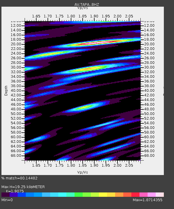
| Estimated Moho Depth: |
19.25 km |
| Estimated Crust Vp/Vs: |
1.91 |
| Assumed Crust Vp: |
5.88 km/s |
| Estimated Crust Vs: |
3.083 km/s |
| Estimated Crust Poisson's Ratio: |
0.31 |
|
| Radial Match: |
80.14482 % |
| Radial Bump: |
400 |
| Transverse Match: |
78.08794 % |
| Transverse Bump: |
400 |
| SOD ConfigId: |
19951751 |
| Insert Time: |
2019-11-28 16:25:03.642 +0000 |
| GWidth: |
2.5 |
| Max Bumps: |
400 |
| Tol: |
0.001 |
|
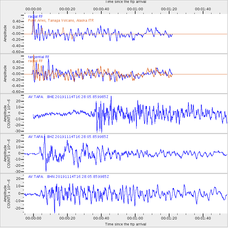
Signal To Noise
| Channel | StoN | STA | LTA |
| AV:TAPA: :BHZ:20191114T16:28:05.859985Z | 4.8144193 | 3.4620764E-6 | 7.1910574E-7 |
| AV:TAPA: :BHN:20191114T16:28:05.859985Z | 1.0306304 | 1.7827832E-6 | 1.7297988E-6 |
| AV:TAPA: :BHE:20191114T16:28:05.859985Z | 1.0454402 | 2.7472065E-6 | 2.6277987E-6 |
| Arrivals |
| Ps | 3.1 SECOND |
| PpPs | 9.2 SECOND |
| PsPs/PpSs | 12 SECOND |


