You are here: Home > Network List > TA - USArray Transportable Network (new EarthScope stations) Stations List
> Station X27A F and S Farms, Texico, NM, USA > Earthquake Result Viewer
X27A F and S Farms, Texico, NM, USA - Earthquake Result Viewer
| Earthquake location: |
Off Coast Of Costa Rica |
| Earthquake latitude/longitude: |
7.9/-85.6 |
| Earthquake time(UTC): |
2009/08/13 (225) 09:37:35 GMT |
| Earthquake Depth: |
10 km |
| Earthquake Magnitude: |
5.8 MW, 5.3 MB |
| Earthquake Catalog/Contributor: |
WHDF/NEIC |
|
| Network: |
TA USArray Transportable Network (new EarthScope stations) |
| Station: |
X27A F and S Farms, Texico, NM, USA |
| Lat/Lon: |
34.65 N/103.10 W |
| Elevation: |
1304 m |
|
| Distance: |
31.0 deg |
| Az: |
331.332 deg |
| Baz: |
144.805 deg |
| Ray Param: |
0.0791717 |
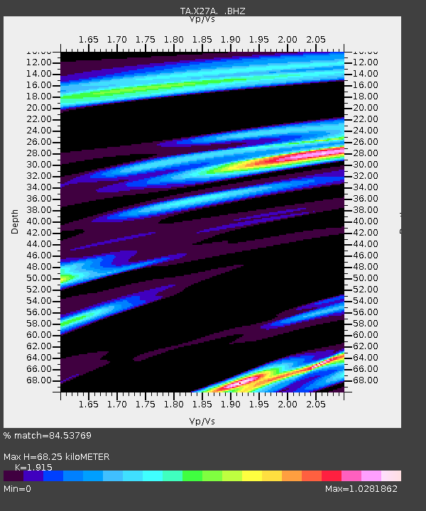
| Estimated Moho Depth: |
68.25 km |
| Estimated Crust Vp/Vs: |
1.91 |
| Assumed Crust Vp: |
6.242 km/s |
| Estimated Crust Vs: |
3.26 km/s |
| Estimated Crust Poisson's Ratio: |
0.31 |
|
| Radial Match: |
84.53769 % |
| Radial Bump: |
352 |
| Transverse Match: |
62.14933 % |
| Transverse Bump: |
400 |
| SOD ConfigId: |
2622 |
| Insert Time: |
2010-03-07 05:49:52.325 +0000 |
| GWidth: |
2.5 |
| Max Bumps: |
400 |
| Tol: |
0.001 |
|

Signal To Noise
| Channel | StoN | STA | LTA |
| TA:X27A: :BHZ:20090813T09:43:22.623987Z | 4.0631866 | 4.371234E-7 | 1.0758142E-7 |
| TA:X27A: :BHN:20090813T09:43:22.623987Z | 3.2351265 | 2.0229233E-7 | 6.2529956E-8 |
| TA:X27A: :BHE:20090813T09:43:22.623987Z | 2.040943 | 1.7156401E-7 | 8.4061156E-8 |
| Arrivals |
| Ps | 11 SECOND |
| PpPs | 30 SECOND |
| PsPs/PpSs | 40 SECOND |


