You are here: Home > Network List > G - GEOSCOPE Stations List
> Station FOMA Nahampoana reservation, Fort Dauphin, Madagascar > Earthquake Result Viewer
FOMA Nahampoana reservation, Fort Dauphin, Madagascar - Earthquake Result Viewer
| Earthquake location: |
Northern Molucca Sea |
| Earthquake latitude/longitude: |
1.5/126.4 |
| Earthquake time(UTC): |
2019/11/14 (318) 16:17:42 GMT |
| Earthquake Depth: |
62 km |
| Earthquake Magnitude: |
7.4 Mi |
| Earthquake Catalog/Contributor: |
NEIC PDE/at |
|
| Network: |
G GEOSCOPE |
| Station: |
FOMA Nahampoana reservation, Fort Dauphin, Madagascar |
| Lat/Lon: |
24.98 S/46.98 E |
| Elevation: |
26 m |
|
| Distance: |
81.0 deg |
| Az: |
244.575 deg |
| Baz: |
84.151 deg |
| Ray Param: |
0.047740523 |
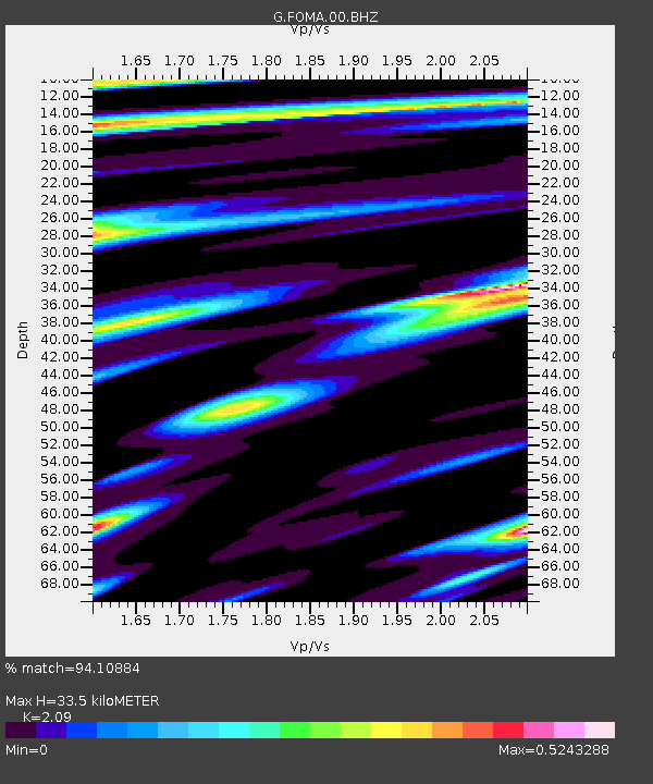
| Estimated Moho Depth: |
33.5 km |
| Estimated Crust Vp/Vs: |
2.09 |
| Assumed Crust Vp: |
6.183 km/s |
| Estimated Crust Vs: |
2.958 km/s |
| Estimated Crust Poisson's Ratio: |
0.35 |
|
| Radial Match: |
94.10884 % |
| Radial Bump: |
291 |
| Transverse Match: |
87.34981 % |
| Transverse Bump: |
400 |
| SOD ConfigId: |
19951751 |
| Insert Time: |
2019-11-28 16:25:21.959 +0000 |
| GWidth: |
2.5 |
| Max Bumps: |
400 |
| Tol: |
0.001 |
|
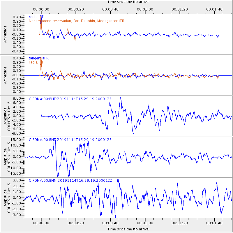
Signal To Noise
| Channel | StoN | STA | LTA |
| G:FOMA:00:BHZ:20191114T16:29:19.200012Z | 3.2863839 | 1.4112634E-6 | 4.2942742E-7 |
| G:FOMA:00:BHN:20191114T16:29:19.200012Z | 0.9631589 | 3.2226555E-7 | 3.345923E-7 |
| G:FOMA:00:BHE:20191114T16:29:19.200012Z | 1.1351235 | 5.8604934E-7 | 5.162869E-7 |
| Arrivals |
| Ps | 6.0 SECOND |
| PpPs | 16 SECOND |
| PsPs/PpSs | 22 SECOND |


