You are here: Home > Network List > TS - TERRAscope (Southern California Seismic Network) Stations List
> Station PAS Pasadena, California, USA > Earthquake Result Viewer
PAS Pasadena, California, USA - Earthquake Result Viewer

| Earthquake location: |
Solomon Islands |
| Earthquake latitude/longitude: |
-9.9/159.1 |
| Earthquake time(UTC): |
1991/02/09 (040) 16:18:58 GMT |
| Earthquake Depth: |
10 km |
| Earthquake Magnitude: |
6.3 MB, 6.9 MS, 6.8 UNKNOWN |
| Earthquake Catalog/Contributor: |
WHDF/NEIC |
|
| Network: |
TS TERRAscope (Southern California Seismic Network) |
| Station: |
PAS Pasadena, California, USA |
| Lat/Lon: |
34.15 N/118.17 W |
| Elevation: |
295 m |
|
| Distance: |
89.5 deg |
| Az: |
55.357 deg |
| Baz: |
257.837 deg |
| Ray Param: |
0.041785587 |
| Estimated Moho Depth: |
22.75 km |
| Estimated Crust Vp/Vs: |
1.92 |
| Assumed Crust Vp: |
6.1 km/s |
| Estimated Crust Vs: |
3.169 km/s |
| Estimated Crust Poisson's Ratio: |
0.32 |
|
| Radial Match: |
92.42822 % |
| Radial Bump: |
400 |
| Transverse Match: |
89.15503 % |
| Transverse Bump: |
400 |
| SOD ConfigId: |
16938 |
| Insert Time: |
2010-02-26 14:34:08.180 +0000 |
| GWidth: |
2.5 |
| Max Bumps: |
400 |
| Tol: |
0.001 |
|
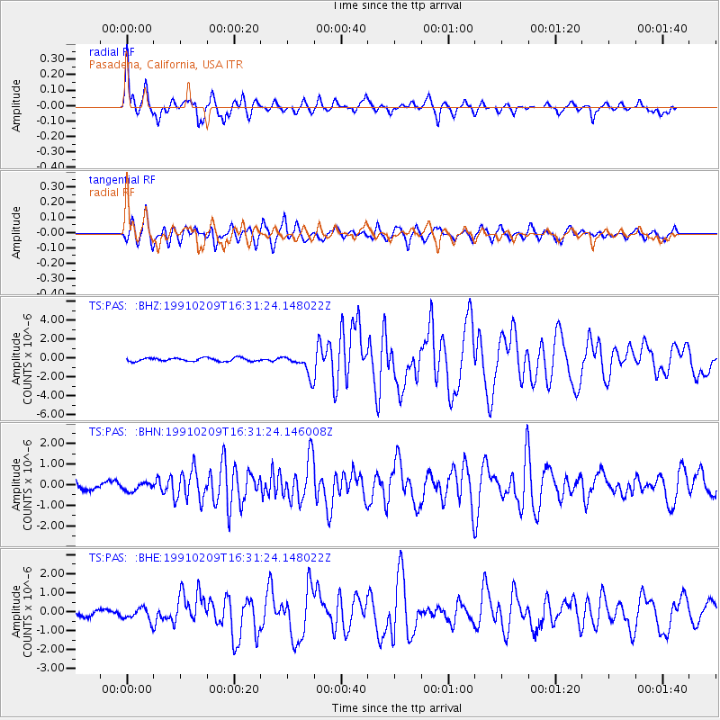
Signal To Noise
| Channel | StoN | STA | LTA |
| TS:PAS: :BHN:19910209T16:31:24.146008Z | 1.2757856 | 1.9514593E-7 | 1.5296139E-7 |
| TS:PAS: :BHE:19910209T16:31:24.148022Z | 2.0958874 | 3.436147E-7 | 1.6394712E-7 |
| TS:PAS: :BHZ:19910209T16:31:24.148022Z | 6.4518085 | 1.1552746E-6 | 1.7906214E-7 |
| Arrivals |
| Ps | 3.5 SECOND |
| PpPs | 11 SECOND |
| PsPs/PpSs | 14 SECOND |


