You are here: Home > Network List > TA - USArray Transportable Network (new EarthScope stations) Stations List
> Station X27A F and S Farms, Texico, NM, USA > Earthquake Result Viewer
X27A F and S Farms, Texico, NM, USA - Earthquake Result Viewer
| Earthquake location: |
Peru-Bolivia Border Region |
| Earthquake latitude/longitude: |
-15.6/-69.3 |
| Earthquake time(UTC): |
2009/09/30 (273) 19:03:17 GMT |
| Earthquake Depth: |
255 km |
| Earthquake Magnitude: |
5.9 MB, 5.8 MW |
| Earthquake Catalog/Contributor: |
WHDF/NEIC |
|
| Network: |
TA USArray Transportable Network (new EarthScope stations) |
| Station: |
X27A F and S Farms, Texico, NM, USA |
| Lat/Lon: |
34.65 N/103.10 W |
| Elevation: |
1304 m |
|
| Distance: |
59.4 deg |
| Az: |
327.786 deg |
| Baz: |
141.449 deg |
| Ray Param: |
0.061375674 |
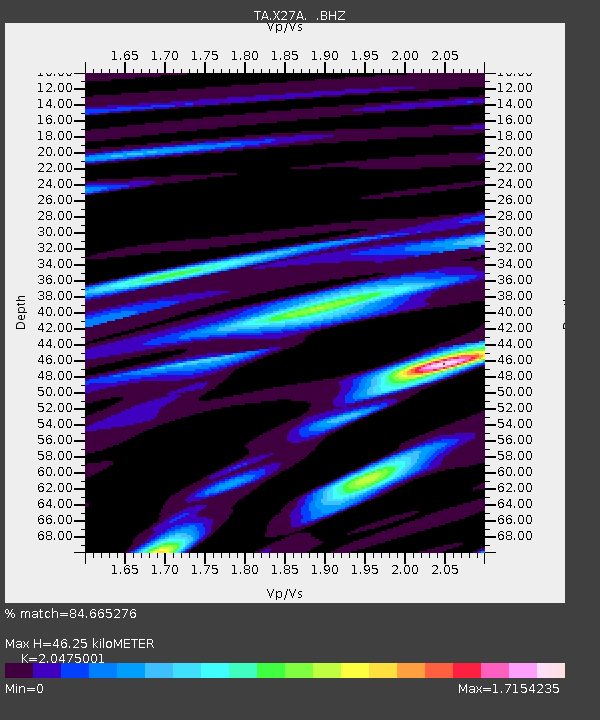
| Estimated Moho Depth: |
46.25 km |
| Estimated Crust Vp/Vs: |
2.05 |
| Assumed Crust Vp: |
6.242 km/s |
| Estimated Crust Vs: |
3.049 km/s |
| Estimated Crust Poisson's Ratio: |
0.34 |
|
| Radial Match: |
84.665276 % |
| Radial Bump: |
400 |
| Transverse Match: |
62.80268 % |
| Transverse Bump: |
400 |
| SOD ConfigId: |
2622 |
| Insert Time: |
2010-03-07 05:49:56.075 +0000 |
| GWidth: |
2.5 |
| Max Bumps: |
400 |
| Tol: |
0.001 |
|

Signal To Noise
| Channel | StoN | STA | LTA |
| TA:X27A: :BHZ:20090930T19:12:22.050Z | 14.117452 | 2.4189326E-6 | 1.7134343E-7 |
| TA:X27A: :BHN:20090930T19:12:22.050Z | 4.21304 | 8.8487394E-7 | 2.1003218E-7 |
| TA:X27A: :BHE:20090930T19:12:22.050Z | 2.6466546 | 8.780966E-7 | 3.3177605E-7 |
| Arrivals |
| Ps | 8.1 SECOND |
| PpPs | 22 SECOND |
| PsPs/PpSs | 30 SECOND |


