You are here: Home > Network List > II - Global Seismograph Network (GSN - IRIS/IDA) Stations List
> Station COCO West Island, Cocos (Keeling) Islands > Earthquake Result Viewer
COCO West Island, Cocos (Keeling) Islands - Earthquake Result Viewer
| Earthquake location: |
Northern Molucca Sea |
| Earthquake latitude/longitude: |
1.5/126.4 |
| Earthquake time(UTC): |
2019/11/14 (318) 16:17:42 GMT |
| Earthquake Depth: |
62 km |
| Earthquake Magnitude: |
7.4 Mi |
| Earthquake Catalog/Contributor: |
NEIC PDE/at |
|
| Network: |
II Global Seismograph Network (GSN - IRIS/IDA) |
| Station: |
COCO West Island, Cocos (Keeling) Islands |
| Lat/Lon: |
12.19 S/96.83 E |
| Elevation: |
1.0 m |
|
| Distance: |
32.4 deg |
| Az: |
244.332 deg |
| Baz: |
67.15 deg |
| Ray Param: |
0.0785446 |
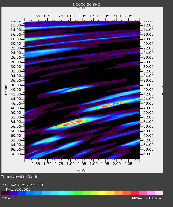
| Estimated Moho Depth: |
54.25 km |
| Estimated Crust Vp/Vs: |
1.81 |
| Assumed Crust Vp: |
4.24 km/s |
| Estimated Crust Vs: |
2.343 km/s |
| Estimated Crust Poisson's Ratio: |
0.28 |
|
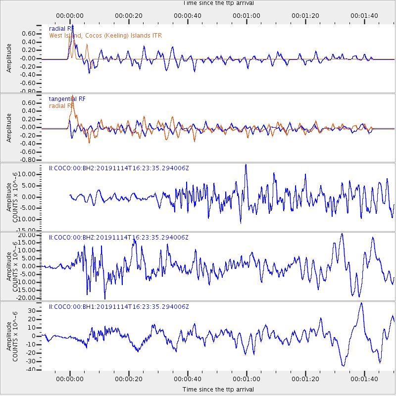
| Radial Match: |
88.45246 % |
| Radial Bump: |
387 |
| Transverse Match: |
60.525803 % |
| Transverse Bump: |
400 |
| SOD ConfigId: |
19951751 |
| Insert Time: |
2019-11-28 16:25:36.597 +0000 |
| GWidth: |
2.5 |
| Max Bumps: |
400 |
| Tol: |
0.001 |
|
Signal To Noise
| Channel | StoN | STA | LTA |
| II:COCO:00:BHZ:20191114T16:23:35.294006Z | 6.7051272 | 4.8169095E-6 | 7.183919E-7 |
| II:COCO:00:BH1:20191114T16:23:35.294006Z | 1.6401377 | 3.041056E-6 | 1.854147E-6 |
| II:COCO:00:BH2:20191114T16:23:35.294006Z | 1.5609955 | 2.0899895E-6 | 1.3388825E-6 |
| Arrivals |
| Ps | 11 SECOND |
| PpPs | 35 SECOND |
| PsPs/PpSs | 46 SECOND |


