You are here: Home > Network List > TA - USArray Transportable Network (new EarthScope stations) Stations List
> Station X27A F and S Farms, Texico, NM, USA > Earthquake Result Viewer
X27A F and S Farms, Texico, NM, USA - Earthquake Result Viewer
| Earthquake location: |
Tonga Islands |
| Earthquake latitude/longitude: |
-16.3/-173.5 |
| Earthquake time(UTC): |
2009/10/02 (275) 01:07:39 GMT |
| Earthquake Depth: |
8.0 km |
| Earthquake Magnitude: |
6.1 MB, 6.0 MS, 6.1 MW, 6.1 MW |
| Earthquake Catalog/Contributor: |
WHDF/NEIC |
|
| Network: |
TA USArray Transportable Network (new EarthScope stations) |
| Station: |
X27A F and S Farms, Texico, NM, USA |
| Lat/Lon: |
34.65 N/103.10 W |
| Elevation: |
1304 m |
|
| Distance: |
83.8 deg |
| Az: |
51.361 deg |
| Baz: |
245.457 deg |
| Ray Param: |
0.045921374 |
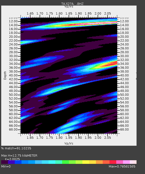
| Estimated Moho Depth: |
12.75 km |
| Estimated Crust Vp/Vs: |
2.00 |
| Assumed Crust Vp: |
6.242 km/s |
| Estimated Crust Vs: |
3.117 km/s |
| Estimated Crust Poisson's Ratio: |
0.33 |
|
| Radial Match: |
91.10235 % |
| Radial Bump: |
399 |
| Transverse Match: |
50.85252 % |
| Transverse Bump: |
367 |
| SOD ConfigId: |
2622 |
| Insert Time: |
2010-03-07 05:49:57.545 +0000 |
| GWidth: |
2.5 |
| Max Bumps: |
400 |
| Tol: |
0.001 |
|

Signal To Noise
| Channel | StoN | STA | LTA |
| TA:X27A: :BHZ:20091002T01:19:37.624014Z | 6.0458903 | 9.4157133E-7 | 1.5573741E-7 |
| TA:X27A: :BHN:20091002T01:19:37.624014Z | 1.0192076 | 1.7662059E-7 | 1.7329207E-7 |
| TA:X27A: :BHE:20091002T01:19:37.624014Z | 1.1932954 | 1.9169028E-7 | 1.6063943E-7 |
| Arrivals |
| Ps | 2.1 SECOND |
| PpPs | 6.0 SECOND |
| PsPs/PpSs | 8.1 SECOND |


