You are here: Home > Network List > TA - USArray Transportable Network (new EarthScope stations) Stations List
> Station X27A F and S Farms, Texico, NM, USA > Earthquake Result Viewer
X27A F and S Farms, Texico, NM, USA - Earthquake Result Viewer
| Earthquake location: |
Vanuatu Islands |
| Earthquake latitude/longitude: |
-13.1/166.5 |
| Earthquake time(UTC): |
2009/10/07 (280) 23:13:48 GMT |
| Earthquake Depth: |
31 km |
| Earthquake Magnitude: |
6.4 MB, 7.2 MS, 7.4 MW, 7.4 MW |
| Earthquake Catalog/Contributor: |
WHDF/NEIC |
|
| Network: |
TA USArray Transportable Network (new EarthScope stations) |
| Station: |
X27A F and S Farms, Texico, NM, USA |
| Lat/Lon: |
34.65 N/103.10 W |
| Elevation: |
1304 m |
|
| Distance: |
97.6 deg |
| Az: |
56.287 deg |
| Baz: |
259.438 deg |
| Ray Param: |
0.040136397 |
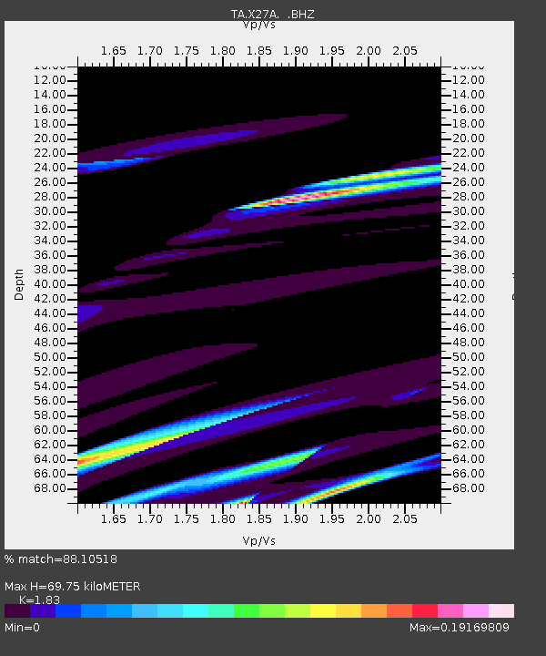
| Estimated Moho Depth: |
69.75 km |
| Estimated Crust Vp/Vs: |
1.83 |
| Assumed Crust Vp: |
6.242 km/s |
| Estimated Crust Vs: |
3.411 km/s |
| Estimated Crust Poisson's Ratio: |
0.29 |
|
| Radial Match: |
88.10518 % |
| Radial Bump: |
400 |
| Transverse Match: |
53.14103 % |
| Transverse Bump: |
216 |
| SOD ConfigId: |
2622 |
| Insert Time: |
2010-03-07 05:50:01.249 +0000 |
| GWidth: |
2.5 |
| Max Bumps: |
400 |
| Tol: |
0.001 |
|

Signal To Noise
| Channel | StoN | STA | LTA |
| TA:X27A: :BHZ:20091007T23:26:48.125027Z | 0.71124184 | 1.5972313E-5 | 2.245694E-5 |
| TA:X27A: :BHN:20091007T23:26:48.125027Z | 2.0938988 | 3.1434323E-5 | 1.50123415E-5 |
| TA:X27A: :BHE:20091007T23:26:48.125027Z | 1.455942 | 2.6799951E-5 | 1.8407292E-5 |
| Arrivals |
| Ps | 9.4 SECOND |
| PpPs | 31 SECOND |
| PsPs/PpSs | 41 SECOND |


