You are here: Home > Network List > TS - TERRAscope (Southern California Seismic Network) Stations List
> Station PAS Pasadena, California, USA > Earthquake Result Viewer
PAS Pasadena, California, USA - Earthquake Result Viewer
| Earthquake location: |
Bering Sea |
| Earthquake latitude/longitude: |
58.4/-175.4 |
| Earthquake time(UTC): |
1991/02/21 (052) 02:35:32 GMT |
| Earthquake Depth: |
10 km |
| Earthquake Magnitude: |
6.3 MB, 6.5 MS, 6.7 UNKNOWN |
| Earthquake Catalog/Contributor: |
WHDF/NEIC |
|
| Network: |
TS TERRAscope (Southern California Seismic Network) |
| Station: |
PAS Pasadena, California, USA |
| Lat/Lon: |
34.15 N/118.17 W |
| Elevation: |
295 m |
|
| Distance: |
44.7 deg |
| Az: |
97.125 deg |
| Baz: |
320.975 deg |
| Ray Param: |
0.07176928 |
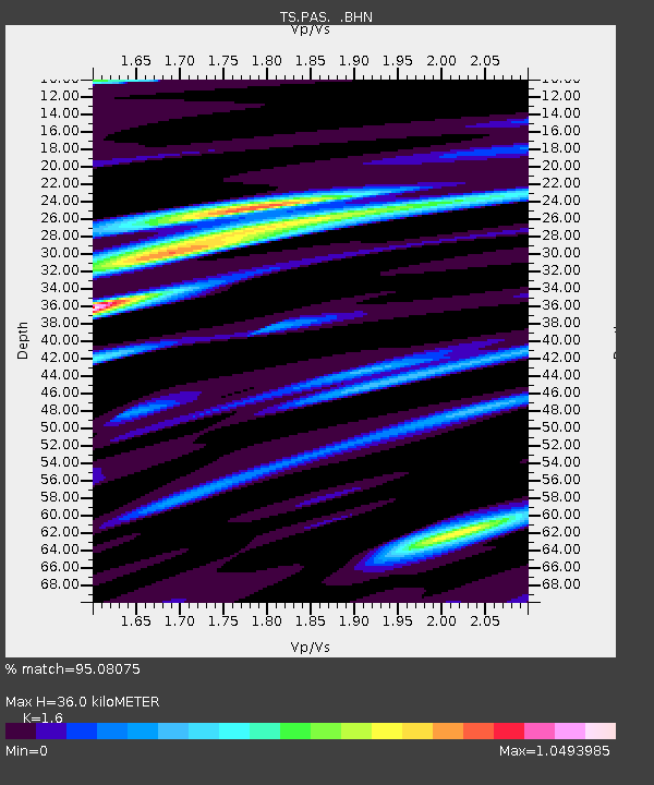
| Estimated Moho Depth: |
36.0 km |
| Estimated Crust Vp/Vs: |
1.60 |
| Assumed Crust Vp: |
6.1 km/s |
| Estimated Crust Vs: |
3.812 km/s |
| Estimated Crust Poisson's Ratio: |
0.18 |
|
| Radial Match: |
95.08075 % |
| Radial Bump: |
400 |
| Transverse Match: |
86.217636 % |
| Transverse Bump: |
400 |
| SOD ConfigId: |
16938 |
| Insert Time: |
2010-02-26 14:34:10.045 +0000 |
| GWidth: |
2.5 |
| Max Bumps: |
400 |
| Tol: |
0.001 |
|
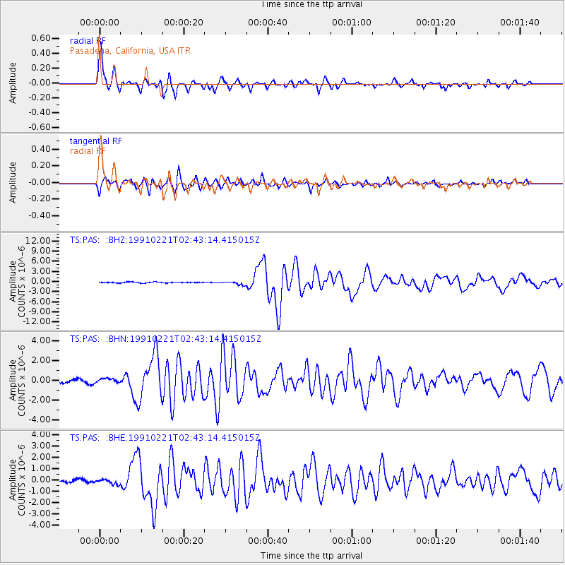
Signal To Noise
| Channel | StoN | STA | LTA |
| TS:PAS: :BHN:19910221T02:43:14.415015Z | 1.4158741 | 2.1426573E-7 | 1.5133105E-7 |
| TS:PAS: :BHE:19910221T02:43:14.415015Z | 2.1550663 | 2.2837592E-7 | 1.05971644E-7 |
| TS:PAS: :BHZ:19910221T02:43:14.415015Z | 3.7961533 | 5.251026E-7 | 1.383249E-7 |
| Arrivals |
| Ps | 3.8 SECOND |
| PpPs | 14 SECOND |
| PsPs/PpSs | 18 SECOND |


