You are here: Home > Network List > MM - Myanmar National Seismic Network Stations List
> Station NGU Ngaung U, Myanmar > Earthquake Result Viewer
NGU Ngaung U, Myanmar - Earthquake Result Viewer
| Earthquake location: |
Northern Molucca Sea |
| Earthquake latitude/longitude: |
1.5/126.4 |
| Earthquake time(UTC): |
2019/11/14 (318) 16:17:42 GMT |
| Earthquake Depth: |
62 km |
| Earthquake Magnitude: |
7.4 Mi |
| Earthquake Catalog/Contributor: |
NEIC PDE/at |
|
| Network: |
MM Myanmar National Seismic Network |
| Station: |
NGU Ngaung U, Myanmar |
| Lat/Lon: |
21.21 N/94.92 E |
| Elevation: |
70 m |
|
| Distance: |
36.4 deg |
| Az: |
304.808 deg |
| Baz: |
118.402 deg |
| Ray Param: |
0.076525316 |
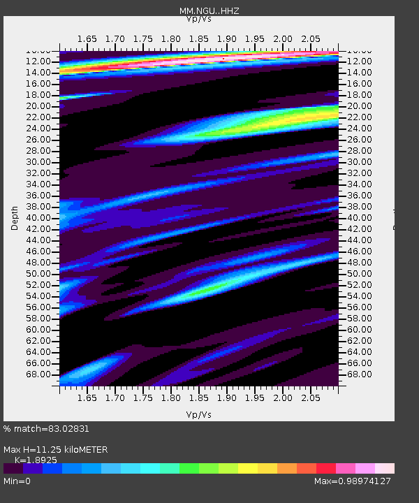
| Estimated Moho Depth: |
11.25 km |
| Estimated Crust Vp/Vs: |
1.89 |
| Assumed Crust Vp: |
6.036 km/s |
| Estimated Crust Vs: |
3.19 km/s |
| Estimated Crust Poisson's Ratio: |
0.31 |
|
| Radial Match: |
83.02831 % |
| Radial Bump: |
285 |
| Transverse Match: |
76.723495 % |
| Transverse Bump: |
385 |
| SOD ConfigId: |
19951751 |
| Insert Time: |
2019-11-28 16:26:18.675 +0000 |
| GWidth: |
2.5 |
| Max Bumps: |
400 |
| Tol: |
0.001 |
|

Signal To Noise
| Channel | StoN | STA | LTA |
| MM:NGU: :HHZ:20191114T16:24:10.160004Z | 23.365494 | 4.8814154E-6 | 2.0891555E-7 |
| MM:NGU: :HHN:20191114T16:24:10.160004Z | 4.2484674 | 7.9561664E-7 | 1.8727145E-7 |
| MM:NGU: :HHE:20191114T16:24:10.160004Z | 4.380325 | 1.11198E-6 | 2.538579E-7 |
| Arrivals |
| Ps | 1.8 SECOND |
| PpPs | 5.1 SECOND |
| PsPs/PpSs | 6.8 SECOND |


