You are here: Home > Network List > TA - USArray Transportable Network (new EarthScope stations) Stations List
> Station X27A F and S Farms, Texico, NM, USA > Earthquake Result Viewer
X27A F and S Farms, Texico, NM, USA - Earthquake Result Viewer
| Earthquake location: |
Baffin Bay |
| Earthquake latitude/longitude: |
75.4/-72.5 |
| Earthquake time(UTC): |
2009/07/07 (188) 19:11:46 GMT |
| Earthquake Depth: |
19 km |
| Earthquake Magnitude: |
5.9 MB, 5.7 MS, 6.1 MW, 6.0 MW |
| Earthquake Catalog/Contributor: |
WHDF/NEIC |
|
| Network: |
TA USArray Transportable Network (new EarthScope stations) |
| Station: |
X27A F and S Farms, Texico, NM, USA |
| Lat/Lon: |
34.65 N/103.10 W |
| Elevation: |
1304 m |
|
| Distance: |
43.3 deg |
| Az: |
217.791 deg |
| Baz: |
10.903 deg |
| Ray Param: |
0.07261915 |
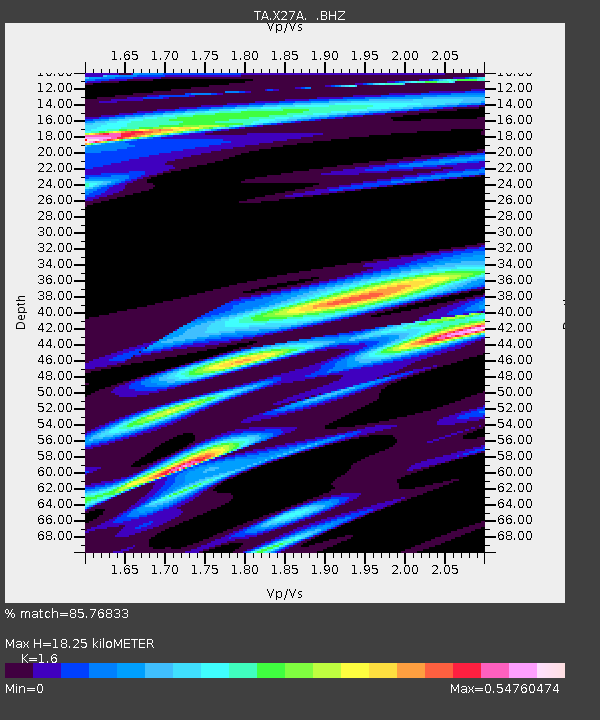
| Estimated Moho Depth: |
18.25 km |
| Estimated Crust Vp/Vs: |
1.60 |
| Assumed Crust Vp: |
6.242 km/s |
| Estimated Crust Vs: |
3.901 km/s |
| Estimated Crust Poisson's Ratio: |
0.18 |
|
| Radial Match: |
85.76833 % |
| Radial Bump: |
289 |
| Transverse Match: |
60.9291 % |
| Transverse Bump: |
321 |
| SOD ConfigId: |
2648 |
| Insert Time: |
2010-03-07 05:50:17.970 +0000 |
| GWidth: |
2.5 |
| Max Bumps: |
400 |
| Tol: |
0.001 |
|

Signal To Noise
| Channel | StoN | STA | LTA |
| TA:X27A: :BHZ:20090707T19:19:16.350015Z | 9.411803 | 1.0578191E-6 | 1.1239281E-7 |
| TA:X27A: :BHN:20090707T19:19:16.350015Z | 5.397922 | 7.203044E-7 | 1.3344105E-7 |
| TA:X27A: :BHE:20090707T19:19:16.350015Z | 1.8031112 | 2.2999556E-7 | 1.2755484E-7 |
| Arrivals |
| Ps | 1.9 SECOND |
| PpPs | 7.1 SECOND |
| PsPs/PpSs | 9.0 SECOND |


