You are here: Home > Network List > TA - USArray Transportable Network (new EarthScope stations) Stations List
> Station C18K Utukok River, AK, USA > Earthquake Result Viewer
C18K Utukok River, AK, USA - Earthquake Result Viewer
| Earthquake location: |
Northern Molucca Sea |
| Earthquake latitude/longitude: |
1.5/126.4 |
| Earthquake time(UTC): |
2019/11/14 (318) 16:17:42 GMT |
| Earthquake Depth: |
62 km |
| Earthquake Magnitude: |
7.4 Mi |
| Earthquake Catalog/Contributor: |
NEIC PDE/at |
|
| Network: |
TA USArray Transportable Network (new EarthScope stations) |
| Station: |
C18K Utukok River, AK, USA |
| Lat/Lon: |
68.65 N/161.19 W |
| Elevation: |
845 m |
|
| Distance: |
82.2 deg |
| Az: |
20.628 deg |
| Baz: |
254.088 deg |
| Ray Param: |
0.046900205 |
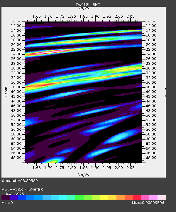
| Estimated Moho Depth: |
23.0 km |
| Estimated Crust Vp/Vs: |
1.70 |
| Assumed Crust Vp: |
5.906 km/s |
| Estimated Crust Vs: |
3.48 km/s |
| Estimated Crust Poisson's Ratio: |
0.23 |
|
| Radial Match: |
95.39989 % |
| Radial Bump: |
400 |
| Transverse Match: |
90.38207 % |
| Transverse Bump: |
400 |
| SOD ConfigId: |
19951751 |
| Insert Time: |
2019-11-28 16:27:03.427 +0000 |
| GWidth: |
2.5 |
| Max Bumps: |
400 |
| Tol: |
0.001 |
|

Signal To Noise
| Channel | StoN | STA | LTA |
| TA:C18K: :BHZ:20191114T16:29:25.525024Z | 5.8968897 | 1.9698318E-6 | 3.340459E-7 |
| TA:C18K: :BHN:20191114T16:29:25.525024Z | 1.5791893 | 5.563523E-7 | 3.5230246E-7 |
| TA:C18K: :BHE:20191114T16:29:25.525024Z | 1.7782047 | 4.839171E-7 | 2.72138E-7 |
| Arrivals |
| Ps | 2.8 SECOND |
| PpPs | 10 SECOND |
| PsPs/PpSs | 13 SECOND |


