You are here: Home > Network List > TA - USArray Transportable Network (new EarthScope stations) Stations List
> Station D28M Stokes Point, YT, CAN > Earthquake Result Viewer
D28M Stokes Point, YT, CAN - Earthquake Result Viewer
| Earthquake location: |
Northern Molucca Sea |
| Earthquake latitude/longitude: |
1.5/126.4 |
| Earthquake time(UTC): |
2019/11/14 (318) 16:17:42 GMT |
| Earthquake Depth: |
62 km |
| Earthquake Magnitude: |
7.4 Mi |
| Earthquake Catalog/Contributor: |
NEIC PDE/at |
|
| Network: |
TA USArray Transportable Network (new EarthScope stations) |
| Station: |
D28M Stokes Point, YT, CAN |
| Lat/Lon: |
69.33 N/138.74 W |
| Elevation: |
32 m |
|
| Distance: |
90.3 deg |
| Az: |
20.721 deg |
| Baz: |
275.075 deg |
| Ray Param: |
0.04167037 |
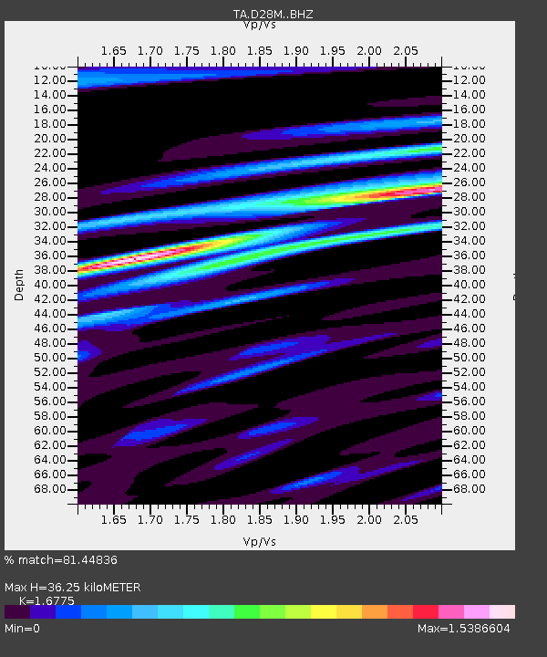
| Estimated Moho Depth: |
36.25 km |
| Estimated Crust Vp/Vs: |
1.68 |
| Assumed Crust Vp: |
6.316 km/s |
| Estimated Crust Vs: |
3.765 km/s |
| Estimated Crust Poisson's Ratio: |
0.22 |
|
| Radial Match: |
81.44836 % |
| Radial Bump: |
400 |
| Transverse Match: |
82.55676 % |
| Transverse Bump: |
400 |
| SOD ConfigId: |
19951751 |
| Insert Time: |
2019-11-28 16:27:11.277 +0000 |
| GWidth: |
2.5 |
| Max Bumps: |
400 |
| Tol: |
0.001 |
|

Signal To Noise
| Channel | StoN | STA | LTA |
| TA:D28M: :BHZ:20191114T16:30:05.025024Z | 4.3510246 | 1.3078817E-6 | 3.0059164E-7 |
| TA:D28M: :BHN:20191114T16:30:05.025024Z | 1.517195 | 4.5564263E-7 | 3.003191E-7 |
| TA:D28M: :BHE:20191114T16:30:05.025024Z | 0.52986884 | 3.7234778E-7 | 7.027169E-7 |
| Arrivals |
| Ps | 4.0 SECOND |
| PpPs | 15 SECOND |
| PsPs/PpSs | 19 SECOND |


