You are here: Home > Network List > TA - USArray Transportable Network (new EarthScope stations) Stations List
> Station X27A F and S Farms, Texico, NM, USA > Earthquake Result Viewer
X27A F and S Farms, Texico, NM, USA - Earthquake Result Viewer
| Earthquake location: |
Sea Of Okhotsk |
| Earthquake latitude/longitude: |
53.9/152.9 |
| Earthquake time(UTC): |
2008/07/05 (187) 02:12:04 GMT |
| Earthquake Depth: |
633 km |
| Earthquake Magnitude: |
6.8 MB, 7.7 MW, 7.7 MW |
| Earthquake Catalog/Contributor: |
WHDF/NEIC |
|
| Network: |
TA USArray Transportable Network (new EarthScope stations) |
| Station: |
X27A F and S Farms, Texico, NM, USA |
| Lat/Lon: |
34.65 N/103.10 W |
| Elevation: |
1304 m |
|
| Distance: |
70.3 deg |
| Az: |
58.199 deg |
| Baz: |
322.389 deg |
| Ray Param: |
0.052873828 |
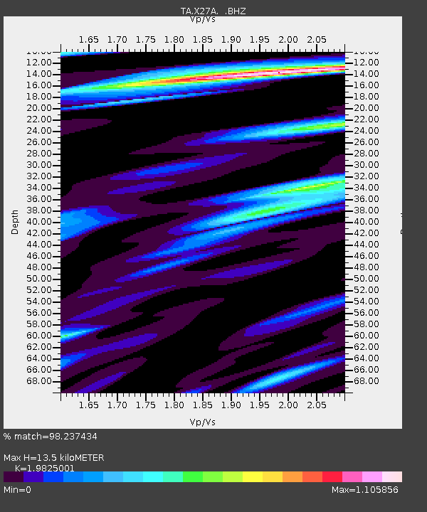
| Estimated Moho Depth: |
13.5 km |
| Estimated Crust Vp/Vs: |
1.98 |
| Assumed Crust Vp: |
6.242 km/s |
| Estimated Crust Vs: |
3.149 km/s |
| Estimated Crust Poisson's Ratio: |
0.33 |
|
| Radial Match: |
98.237434 % |
| Radial Bump: |
400 |
| Transverse Match: |
93.43551 % |
| Transverse Bump: |
400 |
| SOD ConfigId: |
2504 |
| Insert Time: |
2010-03-07 05:50:37.193 +0000 |
| GWidth: |
2.5 |
| Max Bumps: |
400 |
| Tol: |
0.001 |
|

Signal To Noise
| Channel | StoN | STA | LTA |
| TA:X27A: :BHZ:20080705T02:21:44.925007Z | 55.621773 | 9.766771E-6 | 1.7559258E-7 |
| TA:X27A: :BHN:20080705T02:21:44.925007Z | 20.939125 | 2.3839114E-6 | 1.13849616E-7 |
| TA:X27A: :BHE:20080705T02:21:44.925007Z | 11.279705 | 1.7270612E-6 | 1.5311227E-7 |
| Arrivals |
| Ps | 2.2 SECOND |
| PpPs | 6.3 SECOND |
| PsPs/PpSs | 8.5 SECOND |


