You are here: Home > Network List > TA - USArray Transportable Network (new EarthScope stations) Stations List
> Station G31M Satah River, YT, CAN > Earthquake Result Viewer
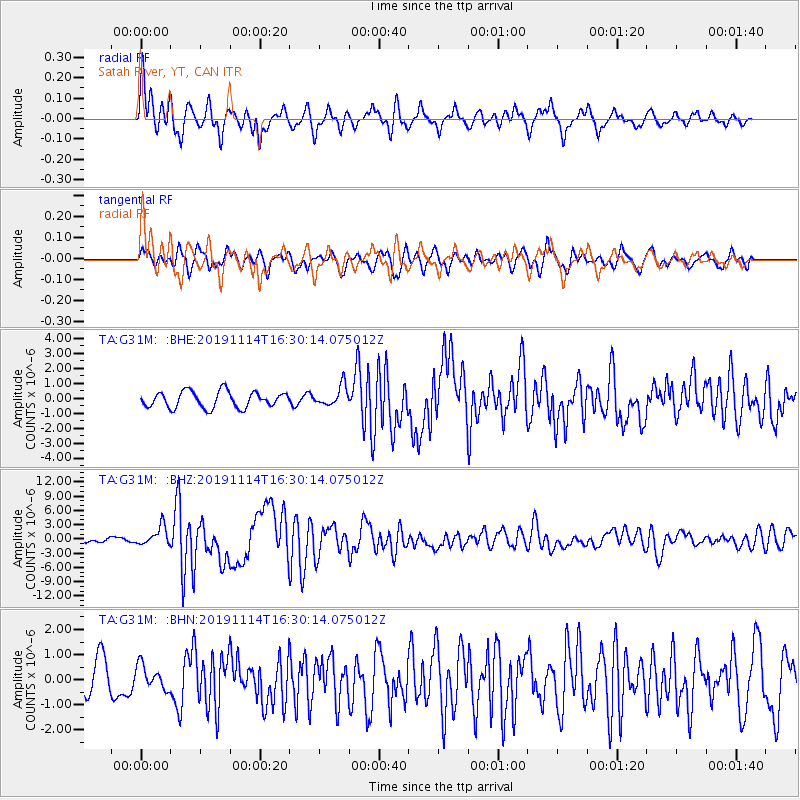
G31M Satah River, YT, CAN - Earthquake Result Viewer
*The percent match for this event was below the threshold and hence no stack was calculated.
| Earthquake location: |
Northern Molucca Sea |
| Earthquake latitude/longitude: |
1.5/126.4 |
| Earthquake time(UTC): |
2019/11/14 (318) 16:17:42 GMT |
| Earthquake Depth: |
62 km |
| Earthquake Magnitude: |
7.4 Mi |
| Earthquake Catalog/Contributor: |
NEIC PDE/at |
|
| Network: |
TA USArray Transportable Network (new EarthScope stations) |
| Station: |
G31M Satah River, YT, CAN |
| Lat/Lon: |
66.92 N/134.27 W |
| Elevation: |
61 m |
|
| Distance: |
92.3 deg |
| Az: |
22.911 deg |
| Baz: |
279.167 deg |
| Ray Param: |
$rayparam |
*The percent match for this event was below the threshold and hence was not used in the summary stack. |
|
| Radial Match: |
79.93204 % |
| Radial Bump: |
400 |
| Transverse Match: |
66.13585 % |
| Transverse Bump: |
400 |
| SOD ConfigId: |
19951751 |
| Insert Time: |
2019-11-28 16:27:33.308 +0000 |
| GWidth: |
2.5 |
| Max Bumps: |
400 |
| Tol: |
0.001 |
|
Signal To Noise
| Channel | StoN | STA | LTA |
| TA:G31M: :BHZ:20191114T16:30:14.075012Z | 4.946956 | 1.9999502E-6 | 4.0427892E-7 |
| TA:G31M: :BHN:20191114T16:30:14.075012Z | 0.6647561 | 4.7137948E-7 | 7.0910136E-7 |
| TA:G31M: :BHE:20191114T16:30:14.075012Z | 1.2229389 | 6.59678E-7 | 5.394202E-7 |
| Arrivals |
| Ps | |
| PpPs | |
| PsPs/PpSs | |


