You are here: Home > Network List > TA - USArray Transportable Network (new EarthScope stations) Stations List
> Station H20K Anotleneega Mountain, AK, USA > Earthquake Result Viewer
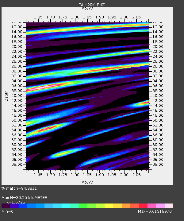
H20K Anotleneega Mountain, AK, USA - Earthquake Result Viewer
| Earthquake location: |
Northern Molucca Sea |
| Earthquake latitude/longitude: |
1.5/126.4 |
| Earthquake time(UTC): |
2019/11/14 (318) 16:17:42 GMT |
| Earthquake Depth: |
62 km |
| Earthquake Magnitude: |
7.4 Mi |
| Earthquake Catalog/Contributor: |
NEIC PDE/at |
|
| Network: |
TA USArray Transportable Network (new EarthScope stations) |
| Station: |
H20K Anotleneega Mountain, AK, USA |
| Lat/Lon: |
65.49 N/154.88 W |
| Elevation: |
514 m |
|
| Distance: |
84.0 deg |
| Az: |
24.29 deg |
| Baz: |
260.339 deg |
| Ray Param: |
0.045701522 |
| Estimated Moho Depth: |
36.25 km |
| Estimated Crust Vp/Vs: |
1.67 |
| Assumed Crust Vp: |
6.566 km/s |
| Estimated Crust Vs: |
3.926 km/s |
| Estimated Crust Poisson's Ratio: |
0.22 |
|
| Radial Match: |
94.3811 % |
| Radial Bump: |
400 |
| Transverse Match: |
90.70907 % |
| Transverse Bump: |
400 |
| SOD ConfigId: |
19951751 |
| Insert Time: |
2019-11-28 16:27:35.530 +0000 |
| GWidth: |
2.5 |
| Max Bumps: |
400 |
| Tol: |
0.001 |
|

Signal To Noise
| Channel | StoN | STA | LTA |
| TA:H20K: :BHZ:20191114T16:29:34.299988Z | 3.2775571 | 1.0847518E-6 | 3.3096353E-7 |
| TA:H20K: :BHN:20191114T16:29:34.299988Z | 0.90538317 | 1.7219615E-7 | 1.9019147E-7 |
| TA:H20K: :BHE:20191114T16:29:34.299988Z | 0.8113451 | 2.554851E-7 | 3.148908E-7 |
| Arrivals |
| Ps | 3.8 SECOND |
| PpPs | 14 SECOND |
| PsPs/PpSs | 18 SECOND |


