You are here: Home > Network List > TS - TERRAscope (Southern California Seismic Network) Stations List
> Station PAS Pasadena, California, USA > Earthquake Result Viewer
PAS Pasadena, California, USA - Earthquake Result Viewer

| Earthquake location: |
Costa Rica |
| Earthquake latitude/longitude: |
10.2/-85.1 |
| Earthquake time(UTC): |
1991/03/16 (075) 06:02:10 GMT |
| Earthquake Depth: |
30 km |
| Earthquake Magnitude: |
5.3 MB, 6.2 MS, 6.2 UNKNOWN |
| Earthquake Catalog/Contributor: |
WHDF/NEIC |
|
| Network: |
TS TERRAscope (Southern California Seismic Network) |
| Station: |
PAS Pasadena, California, USA |
| Lat/Lon: |
34.15 N/118.17 W |
| Elevation: |
295 m |
|
| Distance: |
38.5 deg |
| Az: |
313.426 deg |
| Baz: |
120.449 deg |
| Ray Param: |
0.075478226 |
| Estimated Moho Depth: |
24.25 km |
| Estimated Crust Vp/Vs: |
1.90 |
| Assumed Crust Vp: |
6.1 km/s |
| Estimated Crust Vs: |
3.215 km/s |
| Estimated Crust Poisson's Ratio: |
0.31 |
|
| Radial Match: |
87.68959 % |
| Radial Bump: |
400 |
| Transverse Match: |
71.540535 % |
| Transverse Bump: |
400 |
| SOD ConfigId: |
16938 |
| Insert Time: |
2010-02-26 14:34:12.814 +0000 |
| GWidth: |
2.5 |
| Max Bumps: |
400 |
| Tol: |
0.001 |
|
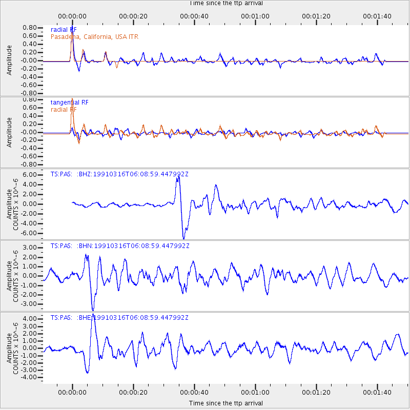
Signal To Noise
| Channel | StoN | STA | LTA |
| TS:PAS: :BHN:19910316T06:08:59.447992Z | 2.1525578 | 8.484618E-7 | 3.9416446E-7 |
| TS:PAS: :BHE:19910316T06:08:59.447992Z | 3.8070698 | 1.1293723E-6 | 2.9665134E-7 |
| TS:PAS: :BHZ:19910316T06:08:59.447992Z | 7.569201 | 2.084071E-6 | 2.7533568E-7 |
| Arrivals |
| Ps | 3.8 SECOND |
| PpPs | 11 SECOND |
| PsPs/PpSs | 15 SECOND |


