You are here: Home > Network List > TA - USArray Transportable Network (new EarthScope stations) Stations List
> Station I28M Miner Creek, YT, CAN > Earthquake Result Viewer
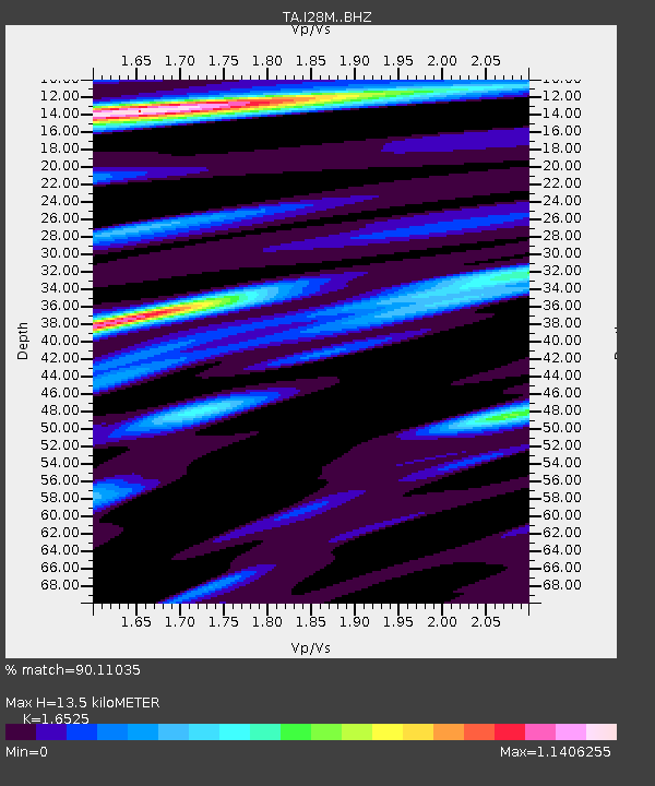
I28M Miner Creek, YT, CAN - Earthquake Result Viewer
| Earthquake location: |
Northern Molucca Sea |
| Earthquake latitude/longitude: |
1.5/126.4 |
| Earthquake time(UTC): |
2019/11/14 (318) 16:17:42 GMT |
| Earthquake Depth: |
62 km |
| Earthquake Magnitude: |
7.4 Mi |
| Earthquake Catalog/Contributor: |
NEIC PDE/at |
|
| Network: |
TA USArray Transportable Network (new EarthScope stations) |
| Station: |
I28M Miner Creek, YT, CAN |
| Lat/Lon: |
65.45 N/139.94 W |
| Elevation: |
1188 m |
|
| Distance: |
90.2 deg |
| Az: |
24.644 deg |
| Baz: |
273.952 deg |
| Ray Param: |
0.041681457 |
| Estimated Moho Depth: |
13.5 km |
| Estimated Crust Vp/Vs: |
1.65 |
| Assumed Crust Vp: |
6.566 km/s |
| Estimated Crust Vs: |
3.973 km/s |
| Estimated Crust Poisson's Ratio: |
0.21 |
|
| Radial Match: |
90.11035 % |
| Radial Bump: |
400 |
| Transverse Match: |
80.93221 % |
| Transverse Bump: |
400 |
| SOD ConfigId: |
19951751 |
| Insert Time: |
2019-11-28 16:27:38.250 +0000 |
| GWidth: |
2.5 |
| Max Bumps: |
400 |
| Tol: |
0.001 |
|

Signal To Noise
| Channel | StoN | STA | LTA |
| TA:I28M: :BHZ:20191114T16:30:04.325012Z | 3.9013536 | 1.5465595E-6 | 3.964161E-7 |
| TA:I28M: :BHN:20191114T16:30:04.325012Z | 1.9736772 | 5.047657E-7 | 2.5574886E-7 |
| TA:I28M: :BHE:20191114T16:30:04.325012Z | 0.749958 | 2.689342E-7 | 3.5859904E-7 |
| Arrivals |
| Ps | 1.4 SECOND |
| PpPs | 5.3 SECOND |
| PsPs/PpSs | 6.7 SECOND |


