You are here: Home > Network List > TS - TERRAscope (Southern California Seismic Network) Stations List
> Station PAS Pasadena, California, USA > Earthquake Result Viewer
PAS Pasadena, California, USA - Earthquake Result Viewer
| Earthquake location: |
Northern Peru |
| Earthquake latitude/longitude: |
-6.0/-77.1 |
| Earthquake time(UTC): |
1991/04/05 (095) 04:19:51 GMT |
| Earthquake Depth: |
33 km |
| Earthquake Magnitude: |
6.5 MB, 6.7 MS, 6.7 UNKNOWN |
| Earthquake Catalog/Contributor: |
WHDF/NEIC |
|
| Network: |
TS TERRAscope (Southern California Seismic Network) |
| Station: |
PAS Pasadena, California, USA |
| Lat/Lon: |
34.15 N/118.17 W |
| Elevation: |
295 m |
|
| Distance: |
55.7 deg |
| Az: |
318.69 deg |
| Baz: |
127.651 deg |
| Ray Param: |
0.06459503 |
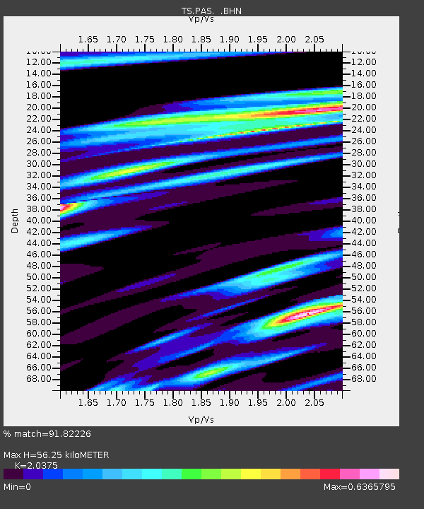
| Estimated Moho Depth: |
56.25 km |
| Estimated Crust Vp/Vs: |
2.04 |
| Assumed Crust Vp: |
6.1 km/s |
| Estimated Crust Vs: |
2.994 km/s |
| Estimated Crust Poisson's Ratio: |
0.34 |
|
| Radial Match: |
91.82226 % |
| Radial Bump: |
294 |
| Transverse Match: |
68.93756 % |
| Transverse Bump: |
400 |
| SOD ConfigId: |
16938 |
| Insert Time: |
2010-02-26 14:34:13.936 +0000 |
| GWidth: |
2.5 |
| Max Bumps: |
400 |
| Tol: |
0.001 |
|
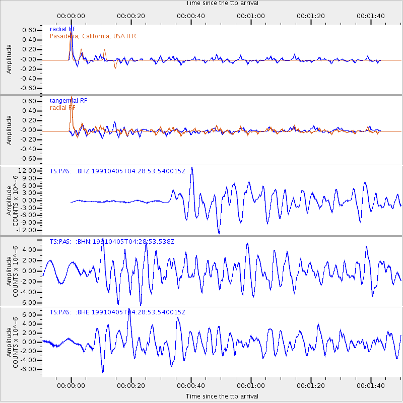
Signal To Noise
| Channel | StoN | STA | LTA |
| TS:PAS: :BHN:19910405T04:28:53.538Z | 1.1847054 | 1.0369131E-6 | 8.752497E-7 |
| TS:PAS: :BHE:19910405T04:28:53.540015Z | 1.6164763 | 8.756842E-7 | 5.417241E-7 |
| TS:PAS: :BHZ:19910405T04:28:53.540015Z | 7.499759 | 1.8048406E-6 | 2.4065315E-7 |
| Arrivals |
| Ps | 10.0 SECOND |
| PpPs | 27 SECOND |
| PsPs/PpSs | 37 SECOND |


