You are here: Home > Network List > TA - USArray Transportable Network (new EarthScope stations) Stations List
> Station D23K Nanushuk River, AK USA > Earthquake Result Viewer
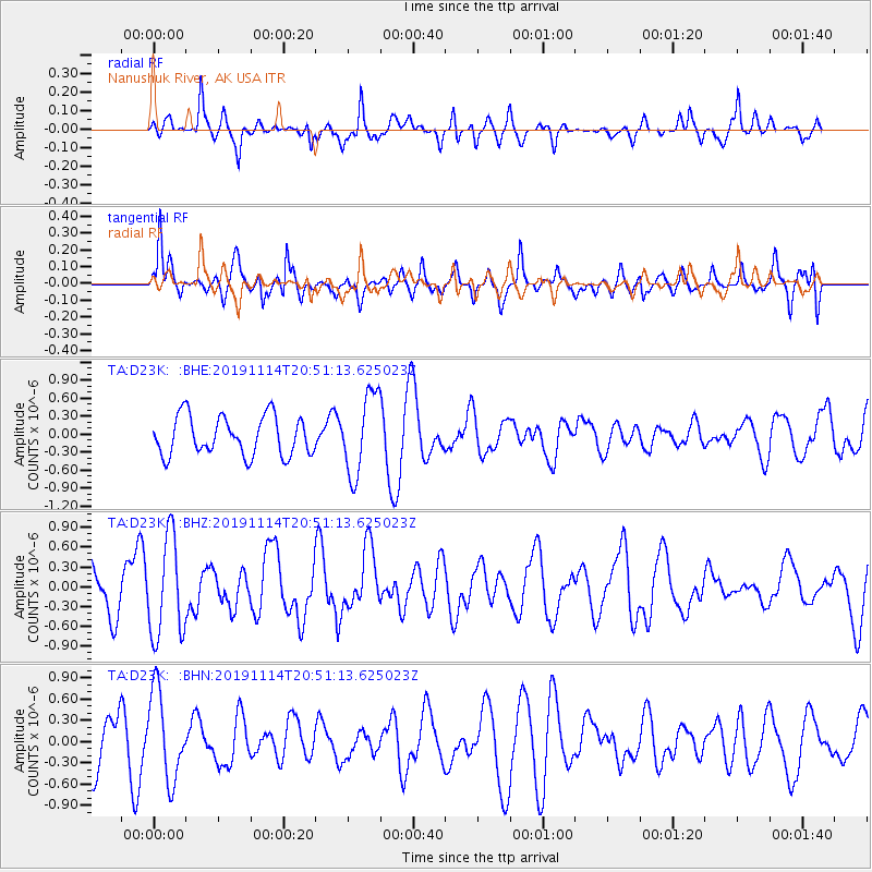
D23K Nanushuk River, AK USA - Earthquake Result Viewer
*The percent match for this event was below the threshold and hence no stack was calculated.
| Earthquake location: |
Northern Molucca Sea |
| Earthquake latitude/longitude: |
1.7/126.4 |
| Earthquake time(UTC): |
2019/11/14 (318) 20:39:05 GMT |
| Earthquake Depth: |
14 km |
| Earthquake Magnitude: |
5.3 Mww |
| Earthquake Catalog/Contributor: |
NEIC PDE/us |
|
| Network: |
TA USArray Transportable Network (new EarthScope stations) |
| Station: |
D23K Nanushuk River, AK USA |
| Lat/Lon: |
68.97 N/150.68 W |
| Elevation: |
406 m |
|
| Distance: |
85.9 deg |
| Az: |
21.052 deg |
| Baz: |
263.999 deg |
| Ray Param: |
$rayparam |
*The percent match for this event was below the threshold and hence was not used in the summary stack. |
|
| Radial Match: |
34.627396 % |
| Radial Bump: |
325 |
| Transverse Match: |
59.681786 % |
| Transverse Bump: |
345 |
| SOD ConfigId: |
19951751 |
| Insert Time: |
2019-11-28 20:46:07.402 +0000 |
| GWidth: |
2.5 |
| Max Bumps: |
400 |
| Tol: |
0.001 |
|
Signal To Noise
| Channel | StoN | STA | LTA |
| TA:D23K: :BHZ:20191114T20:51:13.625023Z | 1.8856621 | 7.528343E-7 | 3.9924134E-7 |
| TA:D23K: :BHN:20191114T20:51:13.625023Z | 1.7576671 | 6.226596E-7 | 3.5425344E-7 |
| TA:D23K: :BHE:20191114T20:51:13.625023Z | 2.0725675 | 6.7001093E-7 | 3.232758E-7 |
| Arrivals |
| Ps | |
| PpPs | |
| PsPs/PpSs | |


