You are here: Home > Network List > TS - TERRAscope (Southern California Seismic Network) Stations List
> Station PAS Pasadena, California, USA > Earthquake Result Viewer
PAS Pasadena, California, USA - Earthquake Result Viewer
| Earthquake location: |
Southern Peru |
| Earthquake latitude/longitude: |
-16.5/-70.7 |
| Earthquake time(UTC): |
1991/05/24 (144) 20:50:55 GMT |
| Earthquake Depth: |
125 km |
| Earthquake Magnitude: |
6.3 MB, 6.8 UNKNOWN |
| Earthquake Catalog/Contributor: |
WHDF/NEIC |
|
| Network: |
TS TERRAscope (Southern California Seismic Network) |
| Station: |
PAS Pasadena, California, USA |
| Lat/Lon: |
34.15 N/118.17 W |
| Elevation: |
295 m |
|
| Distance: |
67.6 deg |
| Az: |
318.648 deg |
| Baz: |
130.154 deg |
| Ray Param: |
0.05649386 |
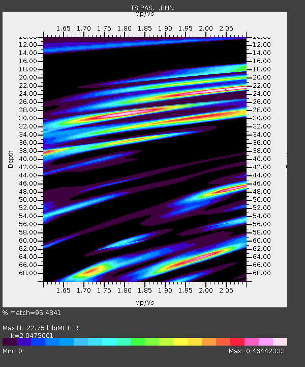
| Estimated Moho Depth: |
22.75 km |
| Estimated Crust Vp/Vs: |
2.05 |
| Assumed Crust Vp: |
6.1 km/s |
| Estimated Crust Vs: |
2.979 km/s |
| Estimated Crust Poisson's Ratio: |
0.34 |
|
| Radial Match: |
95.4841 % |
| Radial Bump: |
391 |
| Transverse Match: |
85.75268 % |
| Transverse Bump: |
400 |
| SOD ConfigId: |
16938 |
| Insert Time: |
2010-02-26 14:34:17.355 +0000 |
| GWidth: |
2.5 |
| Max Bumps: |
400 |
| Tol: |
0.001 |
|

Signal To Noise
| Channel | StoN | STA | LTA |
| TS:PAS: :BHN:19910524T21:01:08.051001Z | 12.045052 | 2.3106827E-6 | 1.9183668E-7 |
| TS:PAS: :BHE:19910524T21:01:08.051001Z | 11.193202 | 2.755127E-6 | 2.461429E-7 |
| TS:PAS: :BHZ:19910524T21:01:08.051001Z | 36.00495 | 7.748433E-6 | 2.1520465E-7 |
| Arrivals |
| Ps | 4.0 SECOND |
| PpPs | 11 SECOND |
| PsPs/PpSs | 15 SECOND |


