You are here: Home > Network List > TA - USArray Transportable Network (new EarthScope stations) Stations List
> Station I17K Unalakleet, AK, USA > Earthquake Result Viewer
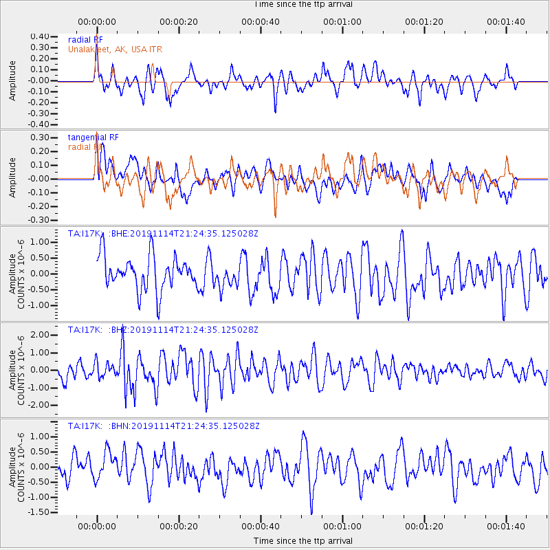
I17K Unalakleet, AK, USA - Earthquake Result Viewer
*The percent match for this event was below the threshold and hence no stack was calculated.
| Earthquake location: |
Northern Molucca Sea |
| Earthquake latitude/longitude: |
1.6/126.5 |
| Earthquake time(UTC): |
2019/11/14 (318) 21:12:53 GMT |
| Earthquake Depth: |
22 km |
| Earthquake Magnitude: |
5.8 Mww |
| Earthquake Catalog/Contributor: |
NEIC PDE/us |
|
| Network: |
TA USArray Transportable Network (new EarthScope stations) |
| Station: |
I17K Unalakleet, AK, USA |
| Lat/Lon: |
63.89 N/160.70 W |
| Elevation: |
105 m |
|
| Distance: |
81.1 deg |
| Az: |
25.341 deg |
| Baz: |
255.196 deg |
| Ray Param: |
$rayparam |
*The percent match for this event was below the threshold and hence was not used in the summary stack. |
|
| Radial Match: |
73.255974 % |
| Radial Bump: |
400 |
| Transverse Match: |
61.065136 % |
| Transverse Bump: |
400 |
| SOD ConfigId: |
19951751 |
| Insert Time: |
2019-11-28 21:20:33.826 +0000 |
| GWidth: |
2.5 |
| Max Bumps: |
400 |
| Tol: |
0.001 |
|
Signal To Noise
| Channel | StoN | STA | LTA |
| TA:I17K: :BHZ:20191114T21:24:35.125028Z | 0.8281224 | 4.2102525E-7 | 5.0840947E-7 |
| TA:I17K: :BHN:20191114T21:24:35.125028Z | 1.2752181 | 5.109939E-7 | 4.0071097E-7 |
| TA:I17K: :BHE:20191114T21:24:35.125028Z | 0.69162357 | 3.6306437E-7 | 5.2494505E-7 |
| Arrivals |
| Ps | |
| PpPs | |
| PsPs/PpSs | |


