You are here: Home > Network List > TS - TERRAscope (Southern California Seismic Network) Stations List
> Station PAS Pasadena, California, USA > Earthquake Result Viewer
PAS Pasadena, California, USA - Earthquake Result Viewer
| Earthquake location: |
Alaska Peninsula |
| Earthquake latitude/longitude: |
54.5/-161.6 |
| Earthquake time(UTC): |
1991/05/30 (150) 13:17:44 GMT |
| Earthquake Depth: |
47 km |
| Earthquake Magnitude: |
6.2 MB, 6.7 MS, 6.8 UNKNOWN |
| Earthquake Catalog/Contributor: |
WHDF/NEIC |
|
| Network: |
TS TERRAscope (Southern California Seismic Network) |
| Station: |
PAS Pasadena, California, USA |
| Lat/Lon: |
34.15 N/118.17 W |
| Elevation: |
295 m |
|
| Distance: |
36.4 deg |
| Az: |
106.032 deg |
| Baz: |
317.504 deg |
| Ray Param: |
0.076602235 |
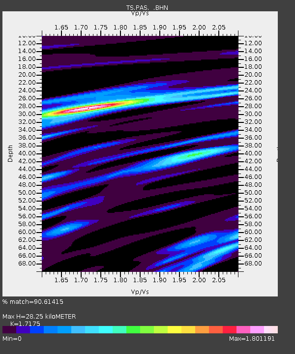
| Estimated Moho Depth: |
28.25 km |
| Estimated Crust Vp/Vs: |
1.72 |
| Assumed Crust Vp: |
6.1 km/s |
| Estimated Crust Vs: |
3.552 km/s |
| Estimated Crust Poisson's Ratio: |
0.24 |
|
| Radial Match: |
90.61415 % |
| Radial Bump: |
364 |
| Transverse Match: |
68.248344 % |
| Transverse Bump: |
400 |
| SOD ConfigId: |
16938 |
| Insert Time: |
2010-02-26 14:34:18.463 +0000 |
| GWidth: |
2.5 |
| Max Bumps: |
400 |
| Tol: |
0.001 |
|

Signal To Noise
| Channel | StoN | STA | LTA |
| TS:PAS: :BHN:19910530T13:24:13.425012Z | 3.3919935 | 6.164008E-7 | 1.8172229E-7 |
| TS:PAS: :BHE:19910530T13:24:13.425012Z | 4.143243 | 7.6791235E-7 | 1.853409E-7 |
| TS:PAS: :BHZ:19910530T13:24:13.425012Z | 8.828293 | 1.4527225E-6 | 1.6455304E-7 |
| Arrivals |
| Ps | 3.6 SECOND |
| PpPs | 12 SECOND |
| PsPs/PpSs | 15 SECOND |


