You are here: Home > Network List > TS - TERRAscope (Southern California Seismic Network) Stations List
> Station PAS Pasadena, California, USA > Earthquake Result Viewer
PAS Pasadena, California, USA - Earthquake Result Viewer
| Earthquake location: |
Fiji Islands Region |
| Earthquake latitude/longitude: |
-20.2/-176.3 |
| Earthquake time(UTC): |
1991/06/09 (160) 07:45:06 GMT |
| Earthquake Depth: |
305 km |
| Earthquake Magnitude: |
6.1 MB |
| Earthquake Catalog/Contributor: |
WHDF/NEIC |
|
| Network: |
TS TERRAscope (Southern California Seismic Network) |
| Station: |
PAS Pasadena, California, USA |
| Lat/Lon: |
34.15 N/118.17 W |
| Elevation: |
295 m |
|
| Distance: |
77.3 deg |
| Az: |
46.22 deg |
| Baz: |
234.862 deg |
| Ray Param: |
0.04956963 |
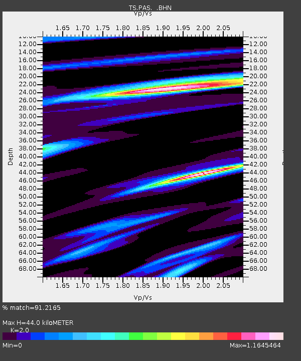
| Estimated Moho Depth: |
44.0 km |
| Estimated Crust Vp/Vs: |
2.00 |
| Assumed Crust Vp: |
6.1 km/s |
| Estimated Crust Vs: |
3.05 km/s |
| Estimated Crust Poisson's Ratio: |
0.33 |
|
| Radial Match: |
91.2165 % |
| Radial Bump: |
400 |
| Transverse Match: |
85.253 % |
| Transverse Bump: |
400 |
| SOD ConfigId: |
16938 |
| Insert Time: |
2010-02-26 14:34:19.607 +0000 |
| GWidth: |
2.5 |
| Max Bumps: |
400 |
| Tol: |
0.001 |
|

Signal To Noise
| Channel | StoN | STA | LTA |
| TS:PAS: :BHN:19910609T07:55:56.821008Z | 12.226536 | 2.0068155E-6 | 1.6413607E-7 |
| TS:PAS: :BHE:19910609T07:55:56.821008Z | 16.824823 | 2.7929543E-6 | 1.6600201E-7 |
| TS:PAS: :BHZ:19910609T07:55:56.821008Z | 36.250183 | 9.443945E-6 | 2.6052132E-7 |
| Arrivals |
| Ps | 7.4 SECOND |
| PpPs | 21 SECOND |
| PsPs/PpSs | 29 SECOND |


