You are here: Home > Network List > TS - TERRAscope (Southern California Seismic Network) Stations List
> Station PAS Pasadena, California, USA > Earthquake Result Viewer
PAS Pasadena, California, USA - Earthquake Result Viewer
| Earthquake location: |
Santiago Del Estero Prov., Arg. |
| Earthquake latitude/longitude: |
-26.8/-63.4 |
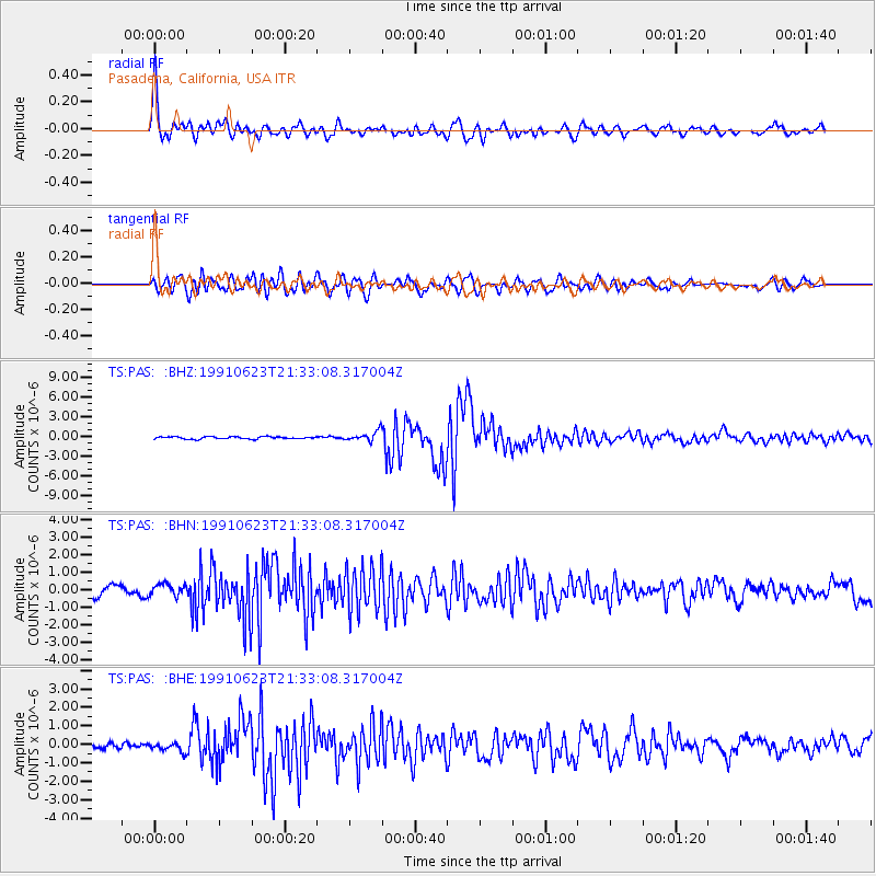
| Earthquake time(UTC): |
1991/06/23 (174) 21:22:30 GMT |
| Earthquake Depth: |
581 km |
| Earthquake Magnitude: |
6.4 MB, 6.2 UNKNOWN |
| Earthquake Catalog/Contributor: |
WHDF/NEIC |
|
| Network: |
TS TERRAscope (Southern California Seismic Network) |
| Station: |
PAS Pasadena, California, USA |
| Lat/Lon: |
34.15 N/118.17 W |
| Elevation: |
295 m |
|
| Distance: |
79.8 deg |
| Az: |
316.507 deg |
| Baz: |
132.129 deg |
| Ray Param: |
0.046915215 |
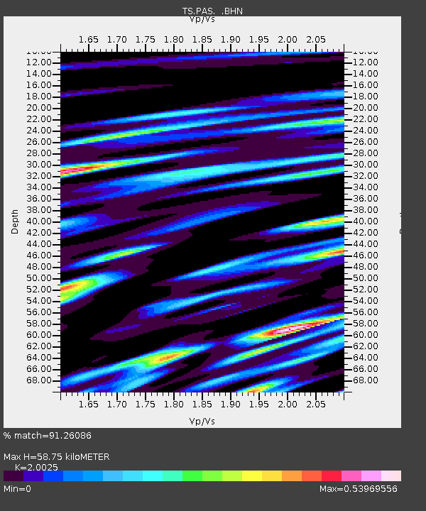
| Estimated Moho Depth: |
58.75 km |
| Estimated Crust Vp/Vs: |
2.00 |
| Assumed Crust Vp: |
6.1 km/s |
| Estimated Crust Vs: |
3.046 km/s |
| Estimated Crust Poisson's Ratio: |
0.33 |
|
| Radial Match: |
91.26086 % |
| Radial Bump: |
400 |
| Transverse Match: |
83.855995 % |
| Transverse Bump: |
400 |
| SOD ConfigId: |
16938 |
| Insert Time: |
2010-02-26 14:34:20.830 +0000 |
| GWidth: |
2.5 |
| Max Bumps: |
400 |
| Tol: |
0.001 |
|
Signal To Noise
| Channel | StoN | STA | LTA |
| TS:PAS: :BHN:19910623T21:33:08.317004Z | 1.4158238 | 3.502366E-7 | 2.47373E-7 |
| TS:PAS: :BHE:19910623T21:33:08.317004Z | 1.450104 | 2.3038241E-7 | 1.5887304E-7 |
| TS:PAS: :BHZ:19910623T21:33:08.317004Z | 4.2960014 | 7.26105E-7 | 1.6901879E-7 |
| Arrivals |
| Ps | 9.9 SECOND |
| PpPs | 28 SECOND |
| PsPs/PpSs | 38 SECOND |


